Showing posts with label history. Show all posts

Wednesday, September 10, 2014

On to Michigan and the Fayette Historic Town Site

After dodging some bad weather leaving Wisconsin, we made our way to Rapid River Michigan and several days of seeing Stonington Peninsula, along with some other great Michigan treasures, like Fayette Historic Town Site.

This 19th Century, well preserved town, was most industrious.  They manufactured charcoal pig iron here from 1867 to 1891, along with lime.   Now in a State Historic Park, visitors can take a walking tour among 20 original structures, including eleven buildings with museum displays and plenty of scenic views of this harbor town of yesterday.

Located on the southern side of the Upper Peninsula on Big Bay de Noc, Lake Michigan, Fayette was at its peak the most productive iron smelting operation in the area. Shortly after the Civil War, this company town grew up around two very large blast furnaces, charcoal kilns, a lime kiln, and a large dock.

About 500 residents lived here, and during its peak in population, half were children. The laborers and skilled tradesman produced over 225,000 tons of pig iron during its 24 years of activity, all splitting up just over $5,000 in payroll each month, They used hardwood from the forest for fuel, and quarried limestone from the bluffs in the harbor to purify the iron ore.  It would be short lived due to the exhaustion of hardwoods, and the Jackson Iron Company closed its Fayette smelting operations in 1891 when the market declined. Although some residents stayed and farmed, many left Fayette.

In 1882 the company announced it would build a lime kiln to manufacture lime used in mortar for masonry, chinking for log houses and plaster for interior walls. The excess was sold to Escanaba, which was a two day trip by stage, or 3 hours by boat across Big Bay de Noc.  In the winter, when the lake froze, residents could ride a stage sled across to Escanaba.

Fayette's central business district separated the have from have nots. Trademen and Supervisors along with their families lived in comfortable frame houses, while simple log homes were taken along the hill, road and shoreline by the unskilled laboring class on the other side of town.

Take a walk on Slag Beach, which was an industrial dump site, where glass like slag, or cinder, mixed with iron can still be found. The Jackson Iron Company used the furnace waste product as a road base and fill material. The beach also served local residents as the landfill, and Fayette was known for not being a "tidy" town.

We found the walking tour great!  You'll want to allow for a couple of hours to see the entire town and its surroundings.  Along the tour you'll find a reconstructed Charcoal Kiln that was used to make fuel for the large furnaces still standing. By the mid 1880's there were over eighty charcoal kilns in the area run by the company.

You'll also see the ruins of the company store, which like many others, was described by one resident as a "pluck me".  The store was destroyed by fire in the 1900's, but it's limestone frame remains tall on the shore of the harbor.

We found this historic park well worth the price of admission to see a bit of history at your own leisure. They've done a great job of maintaining and reconstructing the buildings that are left, with plenty of information to give you a real sense of what life was like here.  For more information see their official website HERE.

See our stay in this area, including our experience with Monarch Butterflies at Peninsula Point Lighthouse, the ghost town of Stonington Point and more via our Photo Blog HERE.

While in this area we stayed at Vagabond Resort just outside of Rapid River, MI.  This is an older RV Park, and though it looks a little run down, we found the management and WIFI to be excellent!  Very helpful and friendly atmosphere, although we probably wouldn't choose this park without the Passport rate.  (Around $27 normal, $13 Passport).


Thursday, September 04, 2014

Fond du Lac to Milwaukee

On our way from Fond du Lac to Milwaukee, we stopped at the Dheinsville Settlement just outside Germantown.  It's an historic 1850's original German settlement with several of the older buildings still standing, including the 1862 Christ Church, an 1854 Hotel, along with a few others. The settlement dates back to 1842, and it was a good stop for a quick fix of history.

Another quick stop found us in Menomonee Falls. A suburb of Milwaukee, it was
established in 1892 on the Menomonee River, which the city has damned creating a water fall. The downtown area has kept it's historic charm despite the influx of population from the city over the years.

The region around the confluence of three rivers, the Milwaukee, Menomonee and Kinnickinnic, into Lake Michigan, was originally inhabited by several Native American tribes, including the Fox, Winnebago, Potawatomi, Ojibwe, Sauk, Menominee and Mascouten. European missionaries and traders were passing through by the late 17th and early 18th century. French Canadian Alexis Laframboise established a trading post here in 1785.

The rivers saw the first official European settlements around 1818, with French Canadian explorer Solomon Juneau establishing Juneautown. It was in competition with two others that formed quickly after, Kilbourntown and Walkers Point.

Leading up to 1840 these settlements went through some intense rivalries that culminated in what is now known as the "Milwaukee Bridge War". Mainly between Juneautown on the east side of the Milwaukee River, and Kilbourntown on the west side, the trouble began when Kilbourntown tried to isolate Juneautown to make it more dependant on them. A planned bridge over the river threatened Kilbourntown's plans, and in 1845 Byron Kilbourn, founder of his settlement, destroyed part of the bridge under construction.  Two smaller bridges were destroyed by men of Juneautown in an attempt to cut off Kilbourn from the east and south side.  It was after this that they decided the best way forward would be to make better efforts to cooperate, and in 1846 the three settlements united into one city as Milwaukee.

The name Milwaukee comes from a Native word meaning "Gathering place by the water", and was known in the early days as Milwacky, Milwarck, Milwauki and even Melleorki.

German immigrants made up a large portion of Milwaukee's early growth. So much so that clubs and societies created here made a lasting impact on American life.  Did you know it was the Germans that created Kindergarten? They also incorpoated sports, music and art into regular school curriculums. By the turn of the 20th Century, Germans made up a third of Milwaukee's population.

Polish immigrants too had and impact on the city, especially in its churches, with steeples that dot the skyline providing some beautiful views with breathtaking architecture. Milwaukee boasts the fifth largest Polish population in the U.S. to this day (around 45,000), but it was as high as 100,000 in 1915.

Other nations' immigrants were also attracted to the city on Lake Michigan, and by 1910 Milwaukee was tied with New York City as having the largest percentage of foreign born residents in the U.S.

In 1960, with a population 91% white, the city was one of the largest in the United States at almost 800,000. However it's population began to decline by the late 1960's as many moved to the burbs, and by 1980 it only had around 630,000 residents.  With it's historic districts and rich immigrant history, the city survived and is on it's way back through re-vitalization and efforts to attract new business. The city saw a population increase over the past decade, it's first since 1960.

Today the city is home to the headquarters of six Fortune 500 companies including Harley-Davidson, Joy Global, Rockwell Automation, Johnson Controls, Manpower, and Northwestern Mutual. Other companies based here including Briggs & Stratton, Master Lock, GE Healthcare and others.

Railroads helped shape the cities future as well, with Milwaukee becoming the largest shipper of wheat in the world in 1862. This of course brought the 'suds'.  Milwaukee was at one time the leading producer of beer in the world, home to four of the worlds largest breweries; Schlitz, Blatz, Pabst and Miller. It has since declined in this regard, but is still home to the major brewer Miller Brewing Company, the second largest in the U.S. Coors also has a brewery in Miller Valley, the oldest still-functioning major brewery in the country. You may recognize some of these brewery's as they were used as the backdrop in many scenes of the popular sitcoms Happy Days and Lavern and Shirley, which were set in Milwaukee.

We couldn't take a brewery tour at Miller Valley due to some electrical problems during our visit, however we especially enjoyed our time around the old Pabst Brewery with it's many buildings abandoned for years. It gave us a glimpse of the past we wouldn't have just months from now, as these old buildings appear to be slated for demolition soon.

There is a lot to see and do in this city, whether touring the famous brewery's, enjoying the many attractions downtown, or even a dip in Lake Michigan on one of the beaches. Oh, and of course there is baseball and the Brewers (I know, there are other sports here too).  Depending on your cup of tea, this could be a weekend long adventure, or you could just be a drive through history buff like us and spend a day taking in the architecture and sites. We don't normally do large cities and like to write about the smaller places in American History the most, but what ever your taste, there is something for everyone in Milwaukee.

After traveling up the lakeside for a while we headed back making a stop in historic Cedarburg. Founded in the early 1840's by Irish and German settlers on Cedar Creek, they have carefully preserved the city's original structures and the downtown looks much as it did over a hundred years ago. In fact, more than 200 buildings of historical significance remain in the town, and remain in use as shops, homes, museums and more.

Industries here included a woolen mill, lumber and flour mills, a nail factory and a brewery, all which prospered after the railroad arrived in 1870. Although it's area population is around 11,000, Cedarburg has kept it's old world charm and we could tell it was a favorite stop for tourists which crowded the shops downtown during our Labor Day weekend visit.

See our visit to the Milwaukee area in images and read more about the history, including that of the famous breweries, in each photo's description via our Photo Blog HERE.

While in this area we stayed at Fond du Lac County Fairgrounds in one of their 18 full hookup sites. $20 a night, and only a few other campers there.  Not a place if you are into scenery, but was great for our purposes.  No wifi, but we had excellent AT&T data here (4Glte).  Fond du Lac has a lot to see and is fairly large compared to what we typically do.  The downtown has a market on certain days, and there's lots of history in this area.  Appears it is sometimes difficult to get into a spot at this fairground. As of this writing you really need to arrive when they are in the office.  If not, you may be without a key to unlock electric and water. We were lucky as there is Donny, a great RV'er that stays there a lot and actually was given the key to help others with.  He had to leave though for the weekend and we saw more than one camper pull up and leave shortly after.  We were told in the office that they are considering upgrading their on-line reservation system and campground next year with new procedures that will eliminate this problem.

Saturday, August 23, 2014

Prairie du Chien Via a Field of Dreams


From August 2014


After leaving Amana Colonies, Kathy and I made our way to Pikes Peak State Park, on the Iowa side of the Mississippi River. But first, we had a quirky side trip to Dyersville and the nearby 
Field of Dreams Movie Site.

Surely most of you have seen the film? Kevin Costner, the cornfield turned into a ball field to bring back a bunch of dead famous Baseball players. Great movie, I don't think I ever pass it up when scrolling through the TV Guide. What's really cool about this, however, is what they had to go through getting this to work.

Director Phil Robinson came to the Dubuque area in early Spring 1988, to make a

decision on one of hundreds of farmsteads under consideration. While on his tour they came upon a farm owned by Don and Becky Lansing. According to information at the site, when Robinson spied it he immediately shouted "That's it! That's my farm!." So in no time they worked with Lansing, moved them to a camper on the other side of the house, and remodeled the home to accommodate filming. Everything going well, except for one major detail. Corn.

It was one of the driest years since the 1930's dust bowl, and they just couldn't get it to grow. Ingenuity paid off though, and after getting approval from local agencies, they dammed a creek that runs through the farm and irrigated the field. It worked so well that the corn grew higher than expected, forcing them to use a foot-high platform for Costner to walk on while filming in the crop.

Building the ball field was also a large task. It would take seven semi-truck loads of sod, along with mixed up busted brick, dye, and dirt to create the infield, but in just four days it was ready.

There were some interesting "Did You Know" facts on the billboard at the movie site. Like the fact that Moonlight Graham, played by Lancaster, was actually a real person, and holds the shortest major league career on record. And the identity of the "voice" in the movie is a closely guarded secret, listed in the credits as "himself".

The field is still just as green as in the movie, and you really get the thrill of being 
there, sitting on the bench where the little girl falls and Burt Lancaster has to save her. Then standing on the mound where Costner first made his pitch to Ray Liotta. And of course having fun with a local star/extra, who played one of the ballplayers in the movie, Kathy doing her fade out into the corn with him. It was a great stop and one we recommend, especially this time of year. Corn looked just about ready to harvest, at least to this geek. The home and farm had been in the Lansing family since 1906, *until 2013 when it was sold to a group of investors "Go The Distance LLC", with plans on turning the area into a major ballpark. We didn't see any construction during our visit, despite the fact that when announced in January 2013 the new ball fields were supposed to get started that Spring. Regardless, we may have been some of the last to see it as it was before the expansion.  This past June they celebrated the 25th Anniversary of the movie's release with several of the stars returning for a trip down memory lane. (*corrected to reflect new ownership, hat tip to reader Albert Hall for bringing that to our attention)

On to our campground. 

Pikes Peak State Park sits at the confluence of the Wisconsin and Mississippi River on the Iowa side and provides visitors and campers with a gorgeous overlook view of the river valley below. The campground for RVs and tents is in the midst of pines, providing a forest experience nature lovers adore, complete with a hiking trail just beyond the river overlook to Bridal Falls.

For AT&T customers, this is no man's land. I don't mean just data either, as many times we didn't even have a connection for voice. So here we were truly disconnected. I know, many of you are thinking that's just the way it should be. But for this geek, it was a challenge not to constantly try to find a signal to at least attempt to see email. It was good for me though and gave Kathy and me some extra time to just sit and enjoy each other's company instead of being glued to our work.

It was raining the morning after we arrived, but we headed out of the park anyway to start exploring the area (to be honest, we were looking for a McDonalds with wifi). After leaving the park you come into historic McGregor, IA.  Founded as McGregor's Landing in 1847, the area was original settled by Alexander McGregor, a direct decedent of Rob Roy McGregor of Scotland. 

McGregor had already been operating a ferry across the Mississippi River to Prairie du Chien, WI for 10 years when he planned the new city. It was incorporated as McGregor in 1857, and it quickly became a major commercial center after the Milwaukee & Mississippi Railroad established a line to Prairie du Chien, connecting Lake Michigan to the mighty river by rail. Other railroads were built from McGregor west, with North McGregor (now Marquette) acting as the rail terminus.  When reaching McGregor from the west, trains were taken apart, ferried across the river, then put back together to make their way to Lake Michigan. 

During the city's peak, the population exploded to over 5,500 and was the busiest shipping port west of Chicago during the 1870s. However, the city would decline just about as fast as it grew when a permanent pontoon bridge was built to connect McGregor and Prairie du Chien, eliminating the need to disassemble the trains, and thus many of the jobs.  Today, McGregor and Marquette (formally North McGregor) have kept their historic charm, but the city has a population of less than a thousand. 

You cross two bridges into Wisconsin, both over sections of the Mississippi River, into historic Prairie Du Chien, the oldest settlement on the Upper Mississippi River, and the second oldest city in the state of Wisconsin, with roots dating back to the late 1600s and the French-Canadian Fur Trade.

St. Feriole Island was the city's earliest hub of activity and was also the site of the Battle of Prairie du Chien in 1814, Wisconsin's only battle in the War of 1812. After the war, the government built Fort Crawford here as part of a chain of forts to secure the U.S. Frontier, and it would become the site of many treaties with Native American's.

One of the big attractions on St. Feriole Island is Villa Louis, a Victorian country estate established in the 1840s by Hercules Dousman, a local fur trader, and entrepreneur. The house that still stands here was built by his son Louis in 1870 and is open to the public for tours under the management of the Wisconsin Historical Society. With over 90 percent of its original furnishings, and a recent restoration to recreate its 1890's appearance, Villa Louis is one of the Midwest's great house museums (open early May through late October).

Other sites on the island include the Fur Trade Museum in the 1850 Stone Brisbois Store, the 1837 Brisbois House, and the Dousman House Hotel. Plan a day here to see the sites and tour the historic buildings.

The on and off again rain, along with some major road construction in town, had Kathy and I heading back to the trailer across the river for a while, but we ventured out again in the afternoon, this time heading north on the Great River Road in Iowa. Along the way, just north of Marquette, you can visit the Effigy Mounds. Here you can see ancient Native American culture and some pretty fantastic views of the Mississippi River. Unfortunately, we didn't have time for a stop, but this historic site run by the National Park Service is likely worth the visit. Plan on a little hiking.

From there we stayed on the River Road heading toward Lansing Iowa. Here we took in parts of the city established in 1851, including the historic Old Stone School built in 1864, then over the 1931 Blackhawk Bridge into Wisconsin. It was a very scenic drive up to Lansing and back down to Praire du Chien, with the road following closely to the river in Wisconsin.

Lots of great history to see and plenty to do in this area of Iowa and Wisconsin. See our travel, including some not talked about in this blog entry, through images via our photoblog HERE

Related Articles:

Great River Road (photo gallery)


RV'ers, Pikes Peak State Park is a beautiful campground, but pretty small. We suggest making reservations, especially in peak travel times.  We had electric but had to fill up the water tank on the way in.  Dump station on the way out.  There are pull-throughs but limited in number. If you want to be in the woods with beautiful surroundings you can't go wrong here. 

Wednesday, August 20, 2014

Amana Colonies


Our first "primary" destination on this journey through the upper-midwest is Amana Colonies in Iowa.  Amana, which means "believe faithfully", was established by the religious group Community of True Inspiration, with origins in Germany.  These German speaking European settlers came to America for many of the same reasons others did, because they didn't agree with the religious experience the churches provided.

Called "True Inspirationists", the group was founded by J.F. Rock and E.L Gruber in 1700's Germany, with both maintaining that the Lutheran Church neglected the spiritual needs of the congregation by getting to into formalized worship and intellectual debate.  Desiring a return to the basics of Christianity, Rock and Gruber attracted many followers with several congregations established throughout Germany, but by the mid 18th Century the movement declined.

Devastated by war and famine in the early 1800's, Germans took comfort in religion and once again the True Inspirationist's began to grow.  Based on the belief that God still spoke through prophets, these new "prophets" were called Werkzeuge, or instruments.  As the group regained it's popularity, Christian Metz would become a Werkzeuge and a guiding force in bringing them to America.

In 1842 the True Inspirationists purchased 5,000 acres near Buffalo, New York, and established a settlement called Ebenezer.  The idea was that all property would be held in common, but then eventually divided among the people based on their contribution.  However the leaders quickly saw the flaw in that plan with disparities in wealth and skills, and with backing of Metz, they adopted a constitution in 1846 that established a permanent communal system.

Reaching a population of 1,200 by 1854, Ebenezer became six villages and thrived.  However, land prices around Buffalo were rising, and the community leaders felt that capitalist and worldly influences were enticing their followers toward materialism, so they decided it was time to move again.

Passing up sites in Kansas, the True Inspirationists settled on a location in the Iowa River valley west of Iowa City. Construction of Amana began in 1855, and as before, they retained the communal system of ownership. Everyone shared in its success, each family was provided what they needed. From goods at the General Store bought with an annual allowance, to free medical care.  In return, the Elders assigned each person a job in the community based on skills and needs.  Most women started working at 14 in the communal kitchens and gardens.  They also tended laundry and a few worked at the woolen mills.  The men had more opportunity in their assignments, working in craft shops, mills, farms, and some educated as doctors and pharmacists.

By the 1860s it had grown to over 20,000 acres with seven villages spaced just a few miles apart.  Known as the Amana Colony, the seven towns were named by their location; West Amana, South Amana, High Amana, East Amana, Middle Amana and the original village of Amana. They would also purchase the entire town of Homestead so they could take advantage of the new railroad line.

Amana's woolen and calico factories, among the first in Iowa, were known throughout the U.S. for superior quality. By the early 1900's the two woolen mills were producing a half million yards of fabric a year, and the calico factory 4,500 yards of cloth a day.  A couple of flour mills processed the community's grains, and crops of potatoes and onions were shipped to Midwest markets.  All the profits were used to purchase goods from outside the colony.

Of course, all this success worried the leaders that the same capitalist influences that brought them to Iowa would again threaten their followers, so they held church services 11 times a week. Every evening, Wednesday, Saturday and Sunday mornings, and Sunday afternoon.

The last Werkzeug, Barbara Heinemann Landmann, died in 1883, but the elders functioned for nearly 50 years afterward without support of divine authority.  Amana became one of America's longest-lived communal societies until June 1, 1932 and what Amana residents call "the Great Change."  Beginning in 1931, social strains of communal living, the loss of the calico print works after World War I, and a fire the previous decade that extensively damaged the woolen and flour mill, along with the national economic depression, came to a head with many True Inspirationists finding the rules to be overly restrictive, and the communal ownership inadequate. So on that June day in 1932, members separated the church from the business enterprises, creating a joint-stock company, and abandoned communalism.  The Amana Society Inc still controls about 26,000 acres of land, and because the land was not divided up, the landscape still reflects its communal heritage.  Today, over 450 communal-era buildings stand in the seven villages, and attract visitors from all over.

We had a great time in Amana Colonies, parking our travel trailer at Amana Colonies RV Park just outside of Amana.  Wonderful set up, in the midst of corn fields, which we will review on RV Park Reviews HERE. In Amana you can enjoy many shops, stores and a museum, and of course some great German cuisine.  Other colonies have museums as well, and some general stores.  It's a good stop for history, and enough to see that you should plan for an entire day in the area at the least.  Depending on your pace, and your pallet, you may consider two.

You can see our adventure at Amana Colonies through images in our Photo Blog HERE.  Additional reading about Utopia's in America can be found HERE.

Friday, August 15, 2014

Legends' Heads North

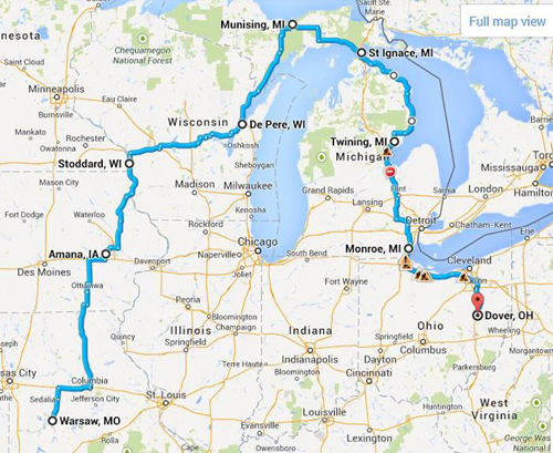
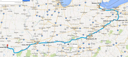
We're heading north this weekend on another long adventure in history! For those of you who have followed our travels before, you know that all plans are "loose" until we get there.  We tend to wander, and get distracted sometimes by bright shiny objects (mainly Ghost Towns and the occasional unexpected grave yard).  So this map is our "current" primary route.  We will stop at some points along the route and do what we call "hub and spoke", where we will explore out around us by 100-200 miles for several days then move on to the next RV park and repeat the process.

Here's our current plan for the first part of our journey

Here's the second half back home

We plan to spend some quality time in central Iowa over the next week and hope you will follow along our travels here and on our Photo Blog

Kathy and Dave, Legends of America


Friday, January 25, 2013

South Bound


Legends' Mobile Motel
We're getting ready for our annual extended winter trip. This year we are headed to Mississippi, Louisiana, with just a little slice of southeast Texas. Many of you on our Facebook FanPage indicated that you would like to see our itinerary and, as we travel, to provide our impressions and reviews of the places that we visit.

This blog is the place for both. Legends of America is our fact and information website, while Legends' Blog is where we post information as we travel, updates for our readers, and any personal thoughts. When we're on the road, most nights we will review our photos and the information on the places that we've visited, then begin to share it with you here. While we have not always, in the past, provided our first impression and reviews, we will begin to do so on this trip.

So, you see everything on the blog first, sometimes months before it ever appears on  Legends of America. Those tales often take a lot of research and tend to take off on many other paths.
Planned Route
Plans are to leave sometime next week. We've got to ensure that all is good with the "mobile motel" and also tie up some loose ends on the business side. We plan to take two days to get to Mississippi, over-nighting at a campground in southeast Missouri. Our first destination is Corinth. From there, we head across the Magnolia State via the Natchez Trace  then to New Orleans, southern Louisiana, and a small slice of southeast Texas before heading north and making our way home via Arkansas

That's all assuming that the weather cooperates. Dave, the resident weatherman in the family, is saying that while Mississippi and Louisiana had higher than average temperatures for January, there is an expected change in the gulf stream for the month of February, making it colder than average. Depending on how cold it gets and other weather conditions, such as rain, ice or snow, it would not be unlike us to abandon plans on a few hours notice and head in another direction. But, until and if, here are the plans for the trip.

When we travel for weeks at a time, we operate on what we call a "hub and spoke" schedule. That means, we find a campground, drop the travel trailer, and make day trips to surrounding areas for several days. The schedule is aggressive -- I load it up in order not to miss anything; but, depending on how time goes, can't guarantee we will make every stop.

Battle of Corinth
Corinth, Mississippi Area:
Natchez Trace
Jackson, Mississippi Area:
Ruins of Windsor
Natchez, Mississippi Area
Tchefuncte River Light House
Southeast Louisiana:
Mississippi Coast Line
Mississippi/Louisiana Coast:
Lafayette, Louisiana Area:

Sabine Pass Battleground
Southwest Lousiana and Southeast Texas:
Central Louisiana:
Natchitoches
Natchitoches, LA and East Texas:
Nacogdoches
Nacogdoches, Texas Area:
The remainder of route will be determined by time available. Choices are to continue through Texas for a family visit near Sherman, checking out several ghost towns along the way, and heading northeast Arkansas through Little Rock and Scenic 7 Byway to Missouri . Alternatively, we'll skip the rest of Texas and head home -- hopefully along the same Arkansas route. 

Whew!!! I'm tired just writing all this down. It's gonna be a whirlwind trip - estimating about 6 weeks. If I've missed important historical sites and you're familiar with the area, please let me know.

Otherwise, we'll "see" ya on the road.

Kathy Weiser-Alexander
Owner/Founder, Legends of America

Monday, July 30, 2012

History Speaks for Itself : Political Ad Ban

Late last week we received an email from a reader in New Mexico complimenting us on our website, but saying that they would not be returning. They wrote "You have a good site. I was very sorry to see that you made it political..."  Political?  I scratched my head at first, until they pointed out what they referred to as 'a link' on some of our pages bashing the President of the United States.  

Turns out the 'link' was an advertisement.  We participate in Google Adsense, which is one way for us to support our travels and writing.  We provide the ad space and Google sells the Ads.  It's a wonderful program and we value each and every advertiser that appears on our site.  However, as the US Elections near, the political advertising from both sides of the isle are increasing, as I'm sure you've noticed. 

As our former reader pointed out, "our country needs less polarization".  We agree. Therefore, moving forward, we have made a decision to 'ban' political advertising on Legends Of America.  

Kathy and I of course have our own views, but we do our best not to use Legends Of America as a political platform for or against any current topic or candidate.  That's one thing great about the past... History speaks for itself.  While this ban effects our bottom line in an already tight economy,  we want all our readers, regardless of their political leanings, or lack there of, to enjoy our stories on American history, legends and lore without the rhetoric of today's politics.

Sincerely, 
Dave Alexander

Ps. For those of you who are searching for information on today's political topics, and have found it hard to find a resource that is non-biased and presents actual "facts" with the original source to back them up, I would like to recommend a new website called "Face The Facts USA".  A project of George Washington University, they just launched today, and are presenting a fact a day, every day until the election, so that American Citizens can cut through the slanted presentation from candidates and agenda driven Media from both sides of the Isle.  We expect Face the Facts USA to hold true to their purpose, as real facts and history are one in the same..They speak for themselves. 
 

Tuesday, June 26, 2012

Jefferson City - Wild West History in Our Own Back Yard

Missouri State Capital Building in Jefferson City
Just about 80 some odd miles away from Legend's home base of Warsaw is the Missouri Capital, Jefferson City.   Kathy and I decided for our sixth wedding anniversary to take an overnight trip there and see some history.  We weren't disappointed. 

Looking toward the Capital from a
Lewis and Clark  marker
Right on the Missouri River, this city wasn't the first capital of Missouri.  St. Louis and then St. Charles served as Missouri Territory capitals first, but then in 1821 territory leaders chose Jefferson City.  The city's name wasn't always Jefferson City either.  It started as Lohman's Landing, and was nothing more than a trading post.  After considering naming it Missouriopolis, the legislature changed it's mind and named it after Thomas Jefferson instead.  They met for the first time in the new capital in 1826, but it wasn't until 1839 that Jefferson City was incorporated.

Lohman Building now a Museum
We toured the downtown area and enjoyed the sites of the capital building and it's views of the river.  We also took in the Lohman Building, built in 1839 by James A. Crump. It served as a grocery store, warehouse, tavern and telegraph office and hotel for the growing city, and is still open today as a museum.

Lincoln University Of Missouri
Jefferson City is also home to Lincoln University. Founded as the Lincoln Institute in 1866 by members of the 62nd and 65th United States Colored Infantry, it's the oldest African American college west of the Mississippi River and has a huge campass.  It changed it's name to Lincoln University of Missouri in 1921, and in 1954 opened its doors to applicants of all races.

Front of what's left of
Missouri State Penitentiary
Of course, our trip would not be complete without a tour of the Missouri State Penitentiary. Also known as "The Walls", it operated from 1836 to 2004, and was the oldest operating penal facility west of the Mississippi River prior to it's closing.  We would highly recommend one of  the tours they give, but you must book in advance.  As of  this writing they are raising funds to maintain the old buildings as they have deteriorated quite a bit since the guards shut the doors 8 years ago.

Gas Chamber at Mo
State Penitentiary
What was really neat about our tour is that the guides were actual guards at the prison.  The history is fascinating, and includes some famous "residents".  Kate Richards O'Hare was brought there in 1919 to serve 5 years for an anti-war speech in North Dakota. So much for free speech at the time.  Her sentence was commuted the next year by President Woodrow Wilson, and she was later given a full pardon by President Calvin Coolidge.  Other famous inmates include Pretty Boy Floyd in 1925; brutal child murderers Carl Austin Hall and Bonnie Heady in the mid 1950's when they were sentenced to death by the Federal Government; World Heavyweight Champion Sonny Liston learned to Box there during his time there beginning in 1950; and Assassin James Earl Ray escaped from the prison in 1967 just months before killing Martin Luther King, Jr.

Dungeon in one of the
buildings at the prison
The guide told us of the hardships suffered by the inmates, especially back in the 1800's.  Horrible conditions that would surely dissuade criminal activity if still in existence today.  Six to eight prisoners stacked on top each other in small cells, and a dark and lonely dungeon where one inmate spent 18 years of his life.  Many stories to tell, so you can bet we'll be adding the history of this place to Legends Of America in the weeks to come.

Jefferson City has quite a bit more history to explore,  and would be worth your time for a visit.