We have a new Photo Blog. Our Photo Blog allows you direct access to many travel related photo galleries and more.
Please enjoy our previous entries here on this blog, dating back a decade, and be sure to check out our latest travels in the new Photo Blog.
Thanks for coming by,
Dave and Kathy, Legends Of America

Legends Of America's Travel Log
Showing posts with label legends of america. Show all posts
Showing posts with label legends of america. Show all posts
Friday, January 30, 2015


Wednesday, August 27, 2014
Old World Wisconsin Worth the Price of Admission +
While staying in the area around Kettle Moraine State Park, our primary destination was Old World Wisconsin. This is an attraction run by the Wisconsin State Historical Society that was worth the admission price and then some.
 To create this outdoor museum, researchers traveled throughout the state looking for authentic buildings representing generations of Wisconsin settlers. Opening in 1976, over 60 historic buildings from around the state have been painstakingly moved here piece by piece, literally numbering boards, bricks and logs to reconstruct them on site. These pieces become "villages and farms" that represent various times in 19th and 20th century Wisconsin. They even have a couple of re-created grave sites that have the exact inscriptions as the originals.
 You experience 1915 at the Finish village, then turn back the clock more to 1839 at the Norwegian area. Each area has its own reenactor's showing what life was like, some even cooking food from the time. There was a squirrel in the pot along with fresh turnips from the garden at the Norwegian village, while they had a little more modern goodies at the Finish place. These are only a couple of examples of life you can see while in here, as Old World Wisconsin is the world's largest museum dedicated to the history of rural life.
 One of our top favorites now, we regretted that we had only 3 hours to tour Old World before it closed for the day. Most definitely allow for at least 4 hours if not the day. Spread over a large area, you can walk from exhibit to exhibit, or catch one of several trams that will drop you off. From General Stores to shoe shops, and barns; wheel makers to bread bakers and historic breeds of animals, even baseball. This museum has something for the entire family to enjoy.
All of it was great, but some of our personal favorites were the 1870's Crossroads Village where you'll find costumed interpreters telling about life as an Irish laundress, Welsh shopkeeper, Bohemian shoemaker, and more. During our visit they were also recreating some of Wisconsin's role in the Civil War, and they had Union troops camped here in the village displaying everyday life during the war.
 Another favorite was the Raspberry One Room School House brought down from around Lake Superior. Representing the late 19th century, the "teacher" will tell you how it was quite hard to keep an instructor there for more than just a few months, and how short lived the school was.
 Of course Kathy's favorite was the barns throughout. Beautiful structures of a time past that have been brought here to be kept intact as they were when originally built. We both loved the Civil War reenactors, and what's great about this place is that different months have different themes. So if we were to be here in October we would experience something new.
Open early May through end of October, Old World Wisconsin should go on your list as a must see. Plan accordingly and check out the various themes and special events via their website HERE.
There's no way this blog could do the museum justice, so we took over 800 photos of our visit and have picked 34 of our faves (may add more) to display in our Old World Wisconsin Photo Blog HERE.
While in this area we stayed at the Rome River Campground and RV Park. We could have stayed in the Kettle Moraine State Park, but they didn't have any spots with hookups left. This second choice was not bad though. Rome is a very small town with a simple General Store (for sale during our visit) right by the campground. But there are larger towns nearby for more groceries, etc. Management was great, wifi was good when it worked (they had some known issues while we were there with their router). AT&T data coverage, while shows solid on the coverage map, was spotty at the campground.
You experience 1915 at the Finish village, then turn back the clock more to 1839 at the Norwegian area. Each area has its own reenactor's showing what life was like, some even cooking food from the time. There was a squirrel in the pot along with fresh turnips from the garden at the Norwegian village, while they had a little more modern goodies at the Finish place. These are only a couple of examples of life you can see while in here, as Old World Wisconsin is the world's largest museum dedicated to the history of rural life.All of it was great, but some of our personal favorites were the 1870's Crossroads Village where you'll find costumed interpreters telling about life as an Irish laundress, Welsh shopkeeper, Bohemian shoemaker, and more. During our visit they were also recreating some of Wisconsin's role in the Civil War, and they had Union troops camped here in the village displaying everyday life during the war.
Another favorite was the Raspberry One Room School House brought down from around Lake Superior. Representing the late 19th century, the "teacher" will tell you how it was quite hard to keep an instructor there for more than just a few months, and how short lived the school was.Open early May through end of October, Old World Wisconsin should go on your list as a must see. Plan accordingly and check out the various themes and special events via their website HERE.
There's no way this blog could do the museum justice, so we took over 800 photos of our visit and have picked 34 of our faves (may add more) to display in our Old World Wisconsin Photo Blog HERE.
While in this area we stayed at the Rome River Campground and RV Park. We could have stayed in the Kettle Moraine State Park, but they didn't have any spots with hookups left. This second choice was not bad though. Rome is a very small town with a simple General Store (for sale during our visit) right by the campground. But there are larger towns nearby for more groceries, etc. Management was great, wifi was good when it worked (they had some known issues while we were there with their router). AT&T data coverage, while shows solid on the coverage map, was spotty at the campground.
Saturday, August 23, 2014
Prairie du Chien Via a Field of Dreams
From August 2014

Surely most of you have seen the film? Kevin Costner, the cornfield turned into a ball field to bring back a bunch of dead famous Baseball players. Great movie, I don't think I ever pass it up when scrolling through the TV Guide. What's really cool about this, however, is what they had to go through getting this to work.
Director Phil Robinson came to the Dubuque area in early Spring 1988, to make a

It was one of the driest years since the 1930's dust bowl, and they just couldn't get it to grow. Ingenuity paid off though, and after getting approval from local agencies, they dammed a creek that runs through the farm and irrigated the field. It worked so well that the corn grew higher than expected, forcing them to use a foot-high platform for Costner to walk on while filming in the crop.
Building the ball field was also a large task. It would take seven semi-truck loads of sod, along with mixed up busted brick, dye, and dirt to create the infield, but in just four days it was ready.
There were some interesting "Did You Know" facts on the billboard at the movie site. Like the fact that Moonlight Graham, played by Lancaster, was actually a real person, and holds the shortest major league career on record. And the identity of the "voice" in the movie is a closely guarded secret, listed in the credits as "himself".
The field is still just as green as in the movie, and you really get the thrill of being
 there, sitting on the bench where the little girl
falls and Burt Lancaster has to save her. Then standing on the mound
where Costner first made his pitch to Ray Liotta. And of course
having fun with a local star/extra, who played one of the ballplayers in the movie, Kathy doing her fade out into the corn with
him. It was a great stop and one we recommend, especially this time
of year. Corn looked just about ready to harvest, at least to this
geek. The home and farm had been in the Lansing family since 1906, *until 2013 when it was sold to a group of investors "Go The Distance LLC", with plans on turning the area into a major ballpark. We didn't see any construction during our visit, despite the fact that when announced in January 2013 the new ball fields were supposed to get started that Spring. Regardless, we may have been some of the last to see it as it was before the expansion. This past June they celebrated the 25th Anniversary of the movie's release with several of the stars returning for a trip down memory
lane. (*corrected to reflect new ownership, hat tip to reader Albert Hall for bringing that to our attention)
On to our campground.
 Pikes
Peak State Park sits at the confluence of the Wisconsin and
Mississippi River on the Iowa side and provides visitors and campers
with a gorgeous overlook view of the river valley below. The
campground for RVs and tents is in the midst of pines, providing a
forest experience nature lovers adore, complete with a hiking trail
just beyond the river overlook to Bridal Falls.
For AT&T customers, this is no man's land. I don't mean just data either, as many times we didn't even have a connection for voice. So here we were truly disconnected. I know, many of you are thinking that's just the way it should be. But for this geek, it was a challenge not to constantly try to find a signal to at least attempt to see email. It was good for me though and gave Kathy and me some extra time to just sit and enjoy each other's company instead of being glued to our work.
It was raining the morning after we arrived, but we headed out of the park anyway to start exploring the area (to be honest, we were looking for a McDonalds with wifi). After leaving the park you come into historic McGregor, IA. Founded as McGregor's Landing in 1847, the area was original settled by Alexander McGregor, a direct decedent of Rob Roy McGregor of Scotland.

During
the city's peak, the population exploded to over 5,500 and was the
busiest shipping port west of Chicago during the 1870s. However, the city would decline just about as fast as it grew when a permanent
pontoon bridge was built to connect McGregor and Prairie du Chien,
eliminating the need to disassemble the trains, and thus many of the
jobs. Today, McGregor and Marquette (formally North McGregor)
have kept their historic charm, but the city has a population of less
than a thousand.
You cross two bridges into Wisconsin, both over sections of the Mississippi River, into historic Prairie Du Chien, the oldest settlement on the Upper Mississippi River, and the second oldest city in the state of Wisconsin, with roots dating back to the late 1600s and the French-Canadian Fur Trade.
St.
Feriole Island was the city's earliest hub of activity and was also
the site of the Battle of Prairie du Chien in 1814, Wisconsin's only
battle in the War of 1812. After the war, the government built Fort
Crawford here as part of a chain of forts to secure the U.S.
Frontier, and it would become the site of many treaties with Native
American's.

Other
sites on the island include the Fur Trade Museum in the 1850 Stone
Brisbois Store, the 1837 Brisbois House, and the Dousman House Hotel.
Plan a day here to see the sites and tour the historic buildings.
The
on and off again rain, along with some major road construction in
town, had Kathy and I heading back to the trailer across the river
for a while, but we ventured out again in the afternoon, this time
heading north on the Great River Road in Iowa. Along the way, just
north of Marquette, you can visit the Effigy Mounds. Here you can
see ancient Native American culture and some pretty fantastic views
of the Mississippi River. Unfortunately, we didn't have time for a
stop, but this historic site run by the National Park Service is
likely worth the visit. Plan on a little hiking.

Lots
of great history to see and plenty to do in this area of Iowa and
Wisconsin. See our travel, including some not talked about in this blog entry, through images via our photoblog HERE.
Related Articles:
Great River Road (photo gallery)
RV'ers, Pikes Peak State Park is a beautiful campground, but pretty small. We suggest making reservations, especially in peak travel times. We had electric but had to fill up the water tank on the way in. Dump station on the way out. There are pull-throughs but limited in number. If you want to be in the woods with beautiful surroundings you can't go wrong here.
Wednesday, August 20, 2014
Amana Colonies
 Our first "primary" destination on this journey through the upper-midwest is Amana Colonies in Iowa. Amana, which means "believe faithfully", was established by the religious group Community of True Inspiration, with origins in Germany. These German speaking European settlers came to America for many of the same reasons others did, because they didn't agree with the religious experience the churches provided.
Called "True Inspirationists", the group was founded by J.F. Rock and E.L Gruber in 1700's Germany, with both maintaining that the Lutheran Church neglected the spiritual needs of the congregation by getting to into formalized worship and intellectual debate. Desiring a return to the basics of Christianity, Rock and Gruber attracted many followers with several congregations established throughout Germany, but by the mid 18th Century the movement declined.
Devastated by war and famine in the early 1800's, Germans took comfort in religion and once again the True Inspirationist's began to grow. Based on the belief that God still spoke through prophets, these new "prophets" were called Werkzeuge, or instruments. As the group regained it's popularity, Christian Metz would become a Werkzeuge and a guiding force in bringing them to America.
In 1842 the True Inspirationists purchased 5,000 acres near Buffalo, New York, and established a settlement called Ebenezer. The idea was that all property would be held in common, but then eventually divided among the people based on their contribution. However the leaders quickly saw the flaw in that plan with disparities in wealth and skills, and with backing of Metz, they adopted a constitution in 1846 that established a permanent communal system.
Reaching a population of 1,200 by 1854, Ebenezer became six villages and thrived. However, land prices around Buffalo were rising, and the community leaders felt that capitalist and worldly influences were enticing their followers toward materialism, so they decided it was time to move again.
Passing up sites in Kansas, the True Inspirationists settled on a location in the Iowa River valley west of Iowa City. Construction of Amana began in 1855, and as before, they retained the communal system of ownership. Everyone shared in its success, each family was provided what they needed. From goods at the General Store bought with an annual allowance, to free medical care. In return, the Elders assigned each person a job in the community based on skills and needs. Most women started working at 14 in the communal kitchens and gardens. They also tended laundry and a few worked at the woolen mills. The men had more opportunity in their assignments, working in craft shops, mills, farms, and some educated as doctors and pharmacists.

Amana's woolen and calico factories, among the first in Iowa, were known throughout the U.S. for superior quality. By the early 1900's the two woolen mills were producing a half million yards of fabric a year, and the calico factory 4,500 yards of cloth a day. A couple of flour mills processed the community's grains, and crops of potatoes and onions were shipped to Midwest markets. All the profits were used to purchase goods from outside the colony.
 Of course, all this success worried the leaders that the same capitalist influences that brought them to Iowa would again threaten their followers, so they held church services 11 times a week. Every evening, Wednesday, Saturday and Sunday mornings, and Sunday afternoon.
The last Werkzeug, Barbara Heinemann Landmann, died in 1883, but the elders functioned for nearly 50 years afterward without support of divine authority. Amana became one of America's longest-lived communal societies until June 1, 1932 and what Amana residents call "the Great Change." Beginning in 1931, social strains of communal living, the loss of the calico print works after World War I, and a fire the previous decade that extensively damaged the woolen and flour mill, along with the national economic depression, came to a head with many True Inspirationists finding the rules to be overly restrictive, and the communal ownership inadequate. So on that June day in 1932, members separated the church from the business enterprises, creating a joint-stock company, and abandoned communalism. The Amana Society Inc still controls about 26,000 acres of land, and because the land was not divided up, the landscape still reflects its communal heritage. Today, over 450 communal-era buildings stand in the seven villages, and attract visitors from all over.
We had a great time in Amana Colonies, parking our travel trailer at Amana Colonies RV Park just outside of Amana. Wonderful set up, in the midst of corn fields, which we will review on RV Park Reviews HERE. In Amana you can enjoy many shops, stores and a museum, and of course some great German cuisine. Other colonies have museums as well, and some general stores. It's a good stop for history, and enough to see that you should plan for an entire day in the area at the least. Depending on your pace, and your pallet, you may consider two.
You can see our adventure at Amana Colonies through images in our Photo Blog HERE. Additional reading about Utopia's in America can be found HERE.
Friday, August 15, 2014
Legends' Heads North
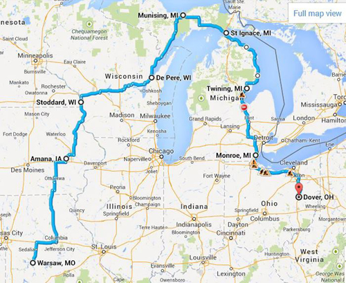
We're heading north this weekend on another long adventure in history! For those of you who have followed our travels before, you know that all plans are "loose" until we get there. We tend to wander, and get distracted sometimes by bright shiny objects (mainly Ghost Towns and the occasional unexpected grave yard). So this map is our "current" primary route. We will stop at some points along the route and do what we call "hub and spoke", where we will explore out around us by 100-200 miles for several days then move on to the next RV park and repeat the process.


Here's our current plan for the first part of our journey
Here's the second half back home
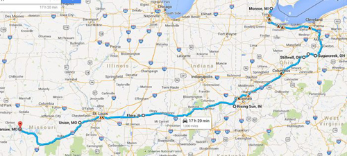
We plan to spend some quality time in central Iowa over the next week and hope you will follow along our travels here and on our Photo Blog.
Kathy and Dave, Legends of America
Friday, July 26, 2013
Las Vegas, NM to Stinnett Tx, via Route 66 and the Old West
 |
| Dilia Church |
After a small jaunt on I-40, we veered back onto the Mother Road at Santa Rosa,
 |
| Sun N Sand in Santa Rosa |
 |
| Old Motor Court in Newkirk |
Between
Santa Rosa and Tucumcari is what we refer to as a ghost town stretch of Route 66 that includes Cuervo, Newkirk and Montoya. These small towns got their start from Ranching and Railroad and for a time they were bustling with activity from the many travelers of Route 66. Today they are a shell of their former self with very few residents. The buildings tell of a time before the interstate when these small communities were important stops. Read more about this stretch HERE.
 |
| Blue Swallow Motel |
This would be all of the Mother Road on this segment of the trip though, as we cut north on Highway 54 for an overnight stay in Logan, just outside of Utte State Park, on our way to more old west history in the Texas Panhandle. (Stayed at Arrowhead RV Park on the east edge of town. Under new ownership for about a month, this was an alright stop for the night with full hookups, but was mostly long term campers working in the area. A little TLC, which the owner is in the process of giving, will go a long way here. Paid $15 (tax included) with our Passport membership).
Logan to Stinnett and Hutchinson County History
 |
| At one time this bar was a bank |
This was a gem of photo ops for Kathy and I, but unfortunately for "me", my camera decided it was time to
 |
| There were quite a few old vehicles on property along the highway in Nara Visa. |
After some quality time in Nara Visa, we pushed onto the Texas Panhandle for Cal Farley's Boys Ranch, which used to be the Old West town of Tascosa. This was once a rival to Dodge City for cattle markets, and was the capital of 10 counties. The post office was established in 1878, and by the 1880's it was already a rough town, famously known for a gun fight in 1886 at the Jenkins Saloon between two panhandle ranch factions that left four dead. You can visit their graves at the Boot Hill cemetery on the way into town.
 Once in Cal Farley's Boys Ranch you need to check into the main office, then walk across the street to the Julian Bivins Museum, housed in the original courthouse. It, and the old school house are the only two original structures remaining from Tascosa, which died as a town after the railroad built 50 miles north of town. By the 1930's the town was dead and Cal Farley's Boys Ranch was built on the site in 1938.
From Cal Farley's we headed onto our destination for the next couple of days, Hutchinson County seat Stinnett Texas.
For Legends' 10th Anniversary, Kathy wanted to pay tribute to her roots in the Texas Panhandle, as it was her Grandmother Irene Foster which gave her the "history bug" as a child. Hutchinson county has a pretty interesting history, especially with the oil industry. Like the wild and wooley town of Borger just a few miles down the road from Stinnett that was once so corrupt that the Governor of Texas had to send in the Texas Rangers. You can read our full story on Borger HERE.
Stinnett wasn't always the county seat. The extinct town of Plemons held that honor for several years after getting it's start in the late 1800's. Hutchinson county is also home to Adobe Walls, the first trading post in this region established back in 1843. Just a marker in a field now, Adobe Walls also has the grave of William Billy Dixon, famous scout, buffalo hunter and Indian Fighter. Dixon was involved with the second "Battle of Adobe Walls", and is credited with being a hero two days into the battle, when a bullet from his Sharps buffalo rifle knocked an Indian off his horse nearly a mile away (perhaps exaggerated. Dixon himself never claimed credit for his "long shot."
 |
| Irene Womble Foster, the inspiration for Legends Of America. |
Kathy's written extensive history on Hutchinson County, it's towns and people which you can see HERE. Be sure to visit the link for Extinct Towns, Ghost Towns and Company Camps to see more about Plemons and other places that used to be part of the rich history here.
You can see our trip in photos via our Facebook photo album HERE.
(We stayed a couple of nights by the city park in Stinnett in a small (3 or 4 space) RV parking area. Full hookups, and it was "Free" for 3 nights, then $10 per night after [no long term campers]. We think it's great promotion for a city to do this, and loved the fact we could take advantage of it. The only thing we would suggest is that the city perform the same care with the RV area that they do with the park, as it was full of good ol' Texas stickers and hardly any grass)
Thursday, February 07, 2013
Corinth, Shiloh and the Natchez Trace
 |
| Planned Route |
 |
| The railroad crossroads are still used today. |
By 1860, the town boasted 1500 residents and was on its way to becoming a prominent town, with several fine homes, hotels, churches and even a school for young women, Corona College. However, when the Civil War began in 1861, both sides recognized the importance of Corinth due to the cross roads of two major rail lines. That set the stage for two significant engagements, a Union siege of the town after taking control of the Tennessee River at the Battle of Shiloh, Tennessee in the spring of 1862, and a most bloody conflict later in the fall as Confederates failed to take back the town.
 |
| Contraband Camp |
Don't miss the Corinth Civil War Interpretive Center, a division of the Shiloh National Military Park, open every day 8-5 except Christmas. Exhibits include interactive displays and multimedia presentations on the Battle of Shiloh and the Siege
of Corinth. The culminating interpretive feature is a commemorative courtyard where stone and flowing water chronicle the birth and growth of the United States, the accompanying rise of sectionalism, key events leading to the Civil War, and a symbolic representation of four years of war. We found the Interpretive Center to be an excellent experience. A must stop on any visit to Corinth.
Read our full article on "The Siege, Battle, History & Attractions of Corinth" HERE.
Also see the Crossroads Museum, where the two critical rail lines meet, and the Black History Museum, featuring a vast permanent collection documenting black history in Corinth and Alcorn County.
Corinth also has a bit of aviation history, as, in 1910, Ernest Waits built and flew one of the first "aeroplanes" in the south. Aviation pioneer Roscoe Turner was born in Corinth.
And, as recent as 2000, Corinth native, Gus McCleod, was the first person to fly around the North Pole in an open cockpit plane. Other notable figures include Cartoonist, Russell Keaton. Today,
Corinth is called home to just under 15,000 people and features plenty of dining and shopping opportunities, including it's historic downtown, as the city boasts "History is only half our story."
Around Corinth
 |
| Corinth Civil War Interpretive Center |
Read our full article on "The Siege, Battle, History & Attractions of Corinth" HERE.
 |
| Crossroads Museum |
Around Corinth
After seeing the city, we took a full day circle trip, first heading south of Corinth, then northeast to Alabama and Tennessee on the Natchez Trace Parkway, westward to Shiloh National Military Park, and back to Corinth. This was a fun excursion,
as it involved plenty of back roads to lessor known places. Following a map we picked up at the Interpretive Center called "A Guide to the Corinth Campaigns of 1862" we headed south of Corinth along the old roads to Rienzi and Jacinto.
Our first stop was to be Union Camp Davies, but, either we were clueless, the map wasn't accurate, or they didn't have it marked, as we could never find it.
Continuing with the map, we made a stop for a few pictures in the small town of Rienzi, established in 1830 and named after an Italian Politician. Though this tiny village continues to boast a population of about 300 souls,
Rienzi's heydays have obviously faded, as its businesses are mostly gone, and the structures that once housed them sit abandoned, providing for a number of "ghost town" photo opportunities.
About eight miles east of Rienzi, we stopped at Jacinto, once the county seat of Tishomingo County and the cultural center of Northeast Mississippi. It was once lined with numerous taverns, businesses, hotels, and even an exclusive boys school.
However, when it was bypassed by the railroad in the 1850's, people began to move. After the Civil War, during Reconstruction, Tishomingo County was split into three counties, and the county seat for Tishmingo County was moved to Iuka.
Today, Jacinto is a true ghost town. There is very little left other than the historic courthouse.
We then pushed on to Iuka. It was here, in September, 1862 that Confederate General Sterling Price and his men raced to stop Union General William Rosecran's troops just south of town. The battle site appears to cross a major highway; but, there is small Confederate cemetery where 263 of Price's men were buried in a mass grave. Iuka also provides a couple of other historic views at its Mineral Springs Park and the Old Tishomingo County Courthouse and Museum.
 Natchez Trace and Shiloh
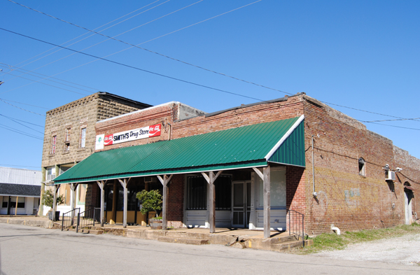 |
| Smith's Drug Store in Rienzi |
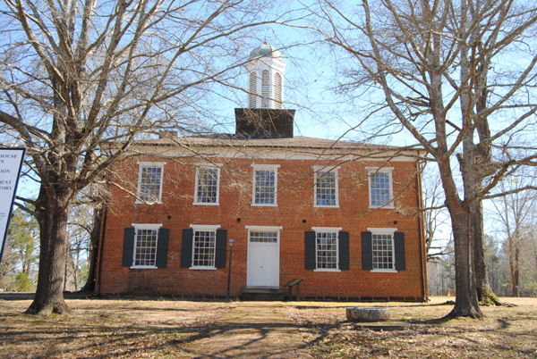 |
| The historic Jacinto courthouse |
We then pushed on to Iuka. It was here, in September, 1862 that Confederate General Sterling Price and his men raced to stop Union General William Rosecran's troops just south of town. The battle site appears to cross a major highway; but, there is small Confederate cemetery where 263 of Price's men were buried in a mass grave. Iuka also provides a couple of other historic views at its Mineral Springs Park and the Old Tishomingo County Courthouse and Museum.
After our brief stop in Iuka, we broke away from our Civil War map and headed across the state line on Lee Highway (72) into Alabama to get on the Natchez Trace Parkway. We'll be writing a lot about the Trace on our Winter Tour,
as we will be on and off it for a good part of our trip. The original Natchez Trace dates back thousands of years to the days of the Mississippi Mound builders. Years later, it was utilized by the Choctaw, Chickasaw, and Natchez tribes
who called the region home and traveled upon the trail on hunting and trading expeditions. By the time the first European explorer Hernando de Soto came to the region in 1541, the path was well worn and the Mississippi Mound builders were gone.
Right after getting on the Trace off Highway 72 you immediately run into Buzzard Roost Spring. Originally called Buzzard Sleep, the name was changed to Buzzard Roost in 1801 by Levi Colbert, a renowned Chickasaw chief. The spring was a water source for the Colbert house which also served as an inn and stand for travelers on the Old Natchez Trace. Levi also helped his brother George Colbert run the Colbert Ferry and their stands were about 2 hours apart by horseback.
 |
| Buzzard Roost |
Continuing on the trace a few more miles, we stop at the site of what was once Colbert's Ferry, which operated across the Tennessee River from 1800 to 1819 and included a stand, or inn, offering travelers a warm meal and shelter during their journey. Looking after their own best interests, the brothers once allegedly charged Andrew Jackson $75,000 to ferry his Tennessee Army across the river. Here, and at about 20 other stands along the Trace, Kaintuck riverboatmen, money-laden businessmen, Indians and outlaws shared a spot of fellowship on a long hazardous road. Today, a beautiful bridge crosses the Tennessee River. This stop includes picnic tables, restrooms, and a boat launch. In fact, despite a chill in the air, a family was having a picnic on the grassy hill overlooking the river when we stopped there.
After crossing the General John Coffee memorial bridge, we came to our first glimpse of an original piece of the historic path. At "Sunken Trace", the trail became so water logged that wagons could not be pulled through, travelers cut new paths through the nearby woods. Here you will see three cuts made to avoid mud into which oxcarts and wagons sank, making progress slow, dangerous and even impossible. Very visible today, we stood in the trail imagining a time long ago as travelers past through these woods.

Shiloh National Military Park
After crossing into Tennessee we exited off the Natchez Trace and headed west for Shiloh National Military Park. Also called the Battle of Pittsburg Landing, this battle took place in Hardin County, Tennessee in April 1862. As a result of the fall of Forts Henry and Donelson, Confederate General Albert Sidney Johnston, the commander in the area, was forced to fall back, giving up Kentucky and much of West and Middle Tennessee. He chose Corinth as the staging area for an offensive against General Ulysses S. Grant and his Army of the Tennessee before the Army of the Ohio, under Major General Don Carlos Buell, could join it. The Confederate retrenchment was a surprise to the Union forces, and it took Grant, with about 40,000 men, some time to mount a southern offensive, along the Tennessee River, toward Pittsburg Landing. Grant received orders to await Buell's Army of the Ohio at Pittsburg Landing.
Attacking the Union troops on the morning of April 6th, the Confederates surprised them, routing many. However, a number of other Federals made determined stands and by afternoon, they had established a battle line at the sunken road, known as the Hornets Nest. Repeated Rebel attacks failed to carry the Hornets Nest, but massed artillery helped to turn the tide as Confederates surrounded the Union troops and captured, killed, or wounded most of them. Johnston had been mortally wounded earlier and his second in command, General P.G.T. Beauregard, took over.
The Union troops established another line covering Pittsburg Landing, anchored with artillery and were augmented by Buell's men who began to arrive and take up positions. Fighting continued until after dark, but the Federals held. By the next morning, the combined Federal forces were some 40,000 strong, outnumbering Beauregard's army of less than 30,000. Beauregard was unaware of the arrival of Buell's army and launched a counterattack in response to a two-mile advance by General William Nelson's division of Buell's army at 6:00 am, which was, at first, successful. Union troops stiffened and began forcing the Confederates back. Beauregard ordered a counterattack, which stopped the Union advance but did not break its battle line. At this point, Beauregard realized that he could not win and, having suffered too many casualties, he retired from the field and headed back to Corinth. Resulting in a Union victory, the estimated casualties (those wounded, killed or missing) were 13,047 Union and 10,699 Confederate. It was the bloodiest battle of the Civil War to that date.
The Union Siege of Corinth would happen just weeks later and Federal forces would take control of the town, and keep control despite the Confederate push later in the fall. During the war years, around 200 top Confederate and Union Generals were stationed in and around Corinth. At least 300,000 troops were in or around the city during the course of the War, making it the largest aggregate number of troops ever assembled in the Western Hemisphere.
These were also the last major Confederate offensives in Mississippi, and the Union Victories enabled General, and later President, Ulysses S. Grant to put his efforts toward his ninth month campaign against Vicksburg. Union troops continued using the town of Corinth as a base for raids into Northern Mississippi, Tennessee and Alabama before finally leaving in January of 1864. Although Confederates would return to Corinth, the end of the war in Mississippi came just a few short months later.
For those who want to learn and understand the costs, human and otherwise, of the Civil War, much can be gleamed from a visit to Corinth and Shiloh. Both the interpretive center in Corinth, and the Shiloh National Military Park were free of charge to enter, both had driving tours, and we give the overall history experience here 10 Stars for excellence.
Here's our Corinth Area Photo Gallery
Here's the Slideshow from the Gallery
_____________________________________________________________
RV Park Reviews
 Ozark Mountain Springs RV Park - Mountain View, Mo - We found the manager on site to be very friendly and helpful. Guided us to our spot and made sure we were aware of the amenities. Only stayed one night. Clean and well kept. Accepts Passport members so we were very happy with the rates. Wifi available, full hookups, pull through sites, shade trees, and pet friendly. We will keep this one in mind for sure on our treks back and forth to the Southeast. We gave this one 7 out of 10 stars.
Corinth RV Park - Corinth, Ms - About 4 miles out of town. Full hookups and some pull through concrete slabs for parking, although we still had to level side to side. Nice and quiet setting while we were there. Park is part of a gun club which is closed in winter months (when we visited), so all was good. No other amenities. No on-site management, honor pay system (OK with us). Would not visit during gun club activity (March-October) with regular shoots on Thursday nights. Water leaked bad enough to submerge the faucet hookup, did not even attempt to use sewer as water was visible in the pipe. Would not stay here at full price of $30/night (Passport rate $15). We gave this one 6 out of 10 stars in our online review, but should have waited until we left after discovering sewer and water issues. So our rating is actually 5 out of 10.
We are using a 22' Travel Trailer. Electric at least 30 amp or more unless noted.
Friday, January 25, 2013
South Bound
We're getting ready for our annual extended winter trip. This year we are headed to Mississippi, Louisiana, with just a little slice of southeast Texas. Many of you on our Facebook FanPage indicated that you would like to see our itinerary and, as we travel, to provide our impressions and reviews of the places that we visit.
This blog is the place for both. Legends of America is our fact and information website, while Legends' Blog is where we post information as we travel, updates for our readers, and any personal thoughts. When we're on the road, most nights we will review our photos and the information on the places that we've visited, then begin to share it with you here. While we have not always, in the past, provided our first impression and reviews, we will begin to do so on this trip.
So, you see everything on the blog first, sometimes months before it ever appears on Legends of America. Those tales often take a lot of research and tend to take off on many other paths.
Plans are to leave sometime next week. We've got to ensure that all is good with the "mobile motel" and also tie up some loose ends on the business side. We plan to take two days to get to Mississippi, over-nighting at a campground in southeast Missouri. Our first destination is Corinth. From there, we head across the Magnolia State via the Natchez Trace then to New Orleans, southern Louisiana, and a small slice of southeast Texas before heading north and making our way home via Arkansas.
That's all assuming that the weather cooperates. Dave, the resident weatherman in the family, is saying that while Mississippi and Louisiana had higher than average temperatures for January, there is an expected change in the gulf stream for the month of February, making it colder than average. Depending on how cold it gets and other weather conditions, such as rain, ice or snow, it would not be unlike us to abandon plans on a few hours notice and head in another direction. But, until and if, here are the plans for the trip.
When we travel for weeks at a time, we operate on what we call a "hub and spoke" schedule. That means, we find a campground, drop the travel trailer, and make day trips to surrounding areas for several days. The schedule is aggressive -- I load it up in order not to miss anything; but, depending on how time goes, can't guarantee we will make every stop.
Corinth, Mississippi Area:
Jackson, Mississippi Area:
Southeast Louisiana:
Mississippi/Louisiana Coast:
Southwest Lousiana and Southeast Texas:
Natchitoches, LA and East Texas:
Nacogdoches, Texas Area:
 |
| Legends' Mobile Motel |
This blog is the place for both. Legends of America is our fact and information website, while Legends' Blog is where we post information as we travel, updates for our readers, and any personal thoughts. When we're on the road, most nights we will review our photos and the information on the places that we've visited, then begin to share it with you here. While we have not always, in the past, provided our first impression and reviews, we will begin to do so on this trip.
So, you see everything on the blog first, sometimes months before it ever appears on Legends of America. Those tales often take a lot of research and tend to take off on many other paths.
|
| Planned Route |
That's all assuming that the weather cooperates. Dave, the resident weatherman in the family, is saying that while Mississippi and Louisiana had higher than average temperatures for January, there is an expected change in the gulf stream for the month of February, making it colder than average. Depending on how cold it gets and other weather conditions, such as rain, ice or snow, it would not be unlike us to abandon plans on a few hours notice and head in another direction. But, until and if, here are the plans for the trip.
When we travel for weeks at a time, we operate on what we call a "hub and spoke" schedule. That means, we find a campground, drop the travel trailer, and make day trips to surrounding areas for several days. The schedule is aggressive -- I load it up in order not to miss anything; but, depending on how time goes, can't guarantee we will make every stop.
 |
| Battle of Corinth |
- Corinth Civil War Interpretive Center
- Historic Downtown Corinth, including the Coca-Cola Museum, Borroums Drug Store, Biggers Hardware, Waits Jewelry
- Natchez Trace from Mississippi border to Collinwood, Tennessee
- Natchez Trace from Mississippi State Line to Tupelo, MS
- Mississippi Final Stands Civil WarInterpretive Center - Brices Crossroads National Battlefield and Battle of Tupelo/Harrisburg
 |
| Natchez Trace |
- Natchez Trace - Tupelo to Jackson

- Natchez Trace from Jackson to Natchez
- City Bus Tour
 |
| Tchefuncte River Light House |
- Lake Pontchartrain Basin Maritime Museum & Tchefuncte River Light House, Madisonville, LA
- Camp Moore Confederate Museum & Cemetery, Tangipahoa, LA
- Longwood (ghost town), East Baton Rouge Parish
- Burtville (ghost town) - South of Baton Rouge
- Bayou Goula Ghost Town, White Castle, LA
 |
| Mississippi Coast Line |
- Phantom Harp of Hawes Mansion Ruins – Pass Christian, Mississippi
- Biloxi Historical Walking Tour
- French Quarter, New Orleans, LA - Including Jackson Square, Bourbon St, Voodoo Spiritual Temple, St. Louis Cemetery No. 1, Spirit Tour, City Sites Bus Tour
Lafayette, Louisiana Area:
- Chitimacha Museum, Charenton, LA
- Acadian Village, Lafayette, LA
- Bayou Vermilion District, Lafayette, LA
- Longfellow-Evangeline State Historic Site, Lafayette, LA
 |
| Sabine Pass Battleground |
- Sam Houston Jones State Park, Lake Charles, LA
- Old Spanish Trail - Westlake, Lake Charles, Sulphur, Vinton, LA
- Sabine Pass Battleground State Park and Historic Site, TX
Central Louisiana:
- Battle of Yellow Bayou, Simmesport, LA
- Marksville State Historic Site, Marksville, LA
- Fort DeRussy, Marksville, LA
- Fort Randolph and Fort Buhlow State Historic Site, Pineville, LA
 |
| Natchitoches |
- Fort St. Jean Baptiste State Historic Site, Natchitoches, LA
- Mansfield State Historic Site, Mansfield, LA
- Adai Indian Nation Cultural Center, Robeline, LA
- Los Adaes State Historic Site, Robeline, LA
- Fort Jesup State Historic Site - Many, LA
- Pleasant Hill Battlefield, Pleasant Hill Battlefield Park Road, Pleasant Hill, TX
- El Camino Real from Natchitoches, LA to Nacogdoches, TX
 |
| Nacogdoches |
- Geneva, TX – Ghostown - The oldest continuously occupied town in East Texas
- St. Augustine, TX Driving Tour
- Nacogdoches Historic Town Center, Nacogdoches, TX
- Ghosts of Nacogdoches Historical Trail
- Millard's Crossing Historic Village, Nacogdoches, TX
- Old University Building, Nacogdoches, TX
- Stone Fort Museum, Nacogdoches, TX
The remainder of route will be determined by time available. Choices are to continue through Texas for a family visit near Sherman, checking out several ghost towns along the way, and heading northeast Arkansas through Little Rock and Scenic 7 Byway to Missouri . Alternatively, we'll skip the rest of Texas and head home -- hopefully along the same Arkansas route.
Whew!!! I'm tired just writing all this down. It's gonna be a whirlwind trip - estimating about 6 weeks. If I've missed important historical sites and you're familiar with the area, please let me know.
Otherwise, we'll "see" ya on the road.
Kathy Weiser-Alexander
Subscribe to:
Posts (Atom)