Showing posts with label tour. Show all posts

Wednesday, September 10, 2014

On to Michigan and the Fayette Historic Town Site

After dodging some bad weather leaving Wisconsin, we made our way to Rapid River Michigan and several days of seeing Stonington Peninsula, along with some other great Michigan treasures, like Fayette Historic Town Site.

This 19th Century, well preserved town, was most industrious.  They manufactured charcoal pig iron here from 1867 to 1891, along with lime.   Now in a State Historic Park, visitors can take a walking tour among 20 original structures, including eleven buildings with museum displays and plenty of scenic views of this harbor town of yesterday.

Located on the southern side of the Upper Peninsula on Big Bay de Noc, Lake Michigan, Fayette was at its peak the most productive iron smelting operation in the area. Shortly after the Civil War, this company town grew up around two very large blast furnaces, charcoal kilns, a lime kiln, and a large dock.

About 500 residents lived here, and during its peak in population, half were children. The laborers and skilled tradesman produced over 225,000 tons of pig iron during its 24 years of activity, all splitting up just over $5,000 in payroll each month, They used hardwood from the forest for fuel, and quarried limestone from the bluffs in the harbor to purify the iron ore.  It would be short lived due to the exhaustion of hardwoods, and the Jackson Iron Company closed its Fayette smelting operations in 1891 when the market declined. Although some residents stayed and farmed, many left Fayette.

In 1882 the company announced it would build a lime kiln to manufacture lime used in mortar for masonry, chinking for log houses and plaster for interior walls. The excess was sold to Escanaba, which was a two day trip by stage, or 3 hours by boat across Big Bay de Noc.  In the winter, when the lake froze, residents could ride a stage sled across to Escanaba.

Fayette's central business district separated the have from have nots. Trademen and Supervisors along with their families lived in comfortable frame houses, while simple log homes were taken along the hill, road and shoreline by the unskilled laboring class on the other side of town.

Take a walk on Slag Beach, which was an industrial dump site, where glass like slag, or cinder, mixed with iron can still be found. The Jackson Iron Company used the furnace waste product as a road base and fill material. The beach also served local residents as the landfill, and Fayette was known for not being a "tidy" town.

We found the walking tour great!  You'll want to allow for a couple of hours to see the entire town and its surroundings.  Along the tour you'll find a reconstructed Charcoal Kiln that was used to make fuel for the large furnaces still standing. By the mid 1880's there were over eighty charcoal kilns in the area run by the company.

You'll also see the ruins of the company store, which like many others, was described by one resident as a "pluck me".  The store was destroyed by fire in the 1900's, but it's limestone frame remains tall on the shore of the harbor.

We found this historic park well worth the price of admission to see a bit of history at your own leisure. They've done a great job of maintaining and reconstructing the buildings that are left, with plenty of information to give you a real sense of what life was like here.  For more information see their official website HERE.

See our stay in this area, including our experience with Monarch Butterflies at Peninsula Point Lighthouse, the ghost town of Stonington Point and more via our Photo Blog HERE.

While in this area we stayed at Vagabond Resort just outside of Rapid River, MI.  This is an older RV Park, and though it looks a little run down, we found the management and WIFI to be excellent!  Very helpful and friendly atmosphere, although we probably wouldn't choose this park without the Passport rate.  (Around $27 normal, $13 Passport).


Thursday, February 07, 2013

Corinth, Shiloh and the Natchez Trace

Planned Route
Our Winter History Tour started off with a sputter. After our departure from the home office in Warsaw Missouri was delayed by severe weather, we finally made it to our first destination a day or two later than anticipated. After making a one night stop at a pleasant little campground in Mountain View, Missouri we made our way to Corinth, Mississippi. This was our first "long term" RV Park stay of the trip (about five days), as there is plenty of history to see in the area. We did our best to ignore the cold, and somehow the weather fit our mission. I think many of us, regardless if it were 100 degrees, would get a cold chill when learning about the humbling history here that claimed so many thousands of lives. (Note: RV Park reviews at the end of this article).

The railroad crossroads
are still used today.
In 1854, the citizens of what was then, Tishomingo County invited two railroad companies to build lines through the largely agricultural area of Northern Mississippi. The Mobile & Ohio, and the Memphis & Charleston railroads soon started construction with their two routes intersecting in the North Central part of the county. "Cross City" grew up at this crossroads and soon changed its name to Corinth.

By 1860, the town boasted 1500 residents and was on its way to becoming a prominent town, with several fine homes, hotels, churches and even a school for young women, Corona College. However, when the Civil War began in 1861, both sides recognized the importance of Corinth due to the cross roads of two major rail lines. That set the stage for two significant engagements, a Union siege of the town after taking control of the Tennessee River at the Battle of Shiloh, Tennessee in the spring of 1862, and a most bloody conflict later in the fall as Confederates failed to take back the town.
Contraband Camp
There's lots to see for history buffs with dozens of historic sites in and around Corinth. Check out the Contraband Camp, which was established after the Union took control, and allowed former slaves, now refugees, a place of safety behind Union lines. This would be an important place for African Americans as it was the first step on the road of freedom and the struggle for equality.

Corinth Civil War Interpretive Center
Don't miss the Corinth Civil War Interpretive Center, a division of the Shiloh National Military Park, open every day 8-5 except Christmas. Exhibits include interactive displays and multimedia presentations on the Battle of Shiloh and the Siege of Corinth. The culminating interpretive feature is a commemorative courtyard where stone and flowing water chronicle the birth and growth of the United States, the accompanying rise of sectionalism, key events leading to the Civil War, and a symbolic representation of four years of war. We found the Interpretive Center to be an excellent experience. A must stop on any visit to Corinth.

Read our full article on "The Siege, Battle, History & Attractions of Corinth" HERE.

Crossroads Museum
Also see the Crossroads Museum, where the two critical rail lines meet, and the Black History Museum, featuring a vast permanent collection documenting black history in Corinth and Alcorn County. Corinth also has a bit of aviation history, as, in 1910, Ernest Waits built and flew one of the first "aeroplanes" in the south. Aviation pioneer Roscoe Turner was born in Corinth. And, as recent as 2000, Corinth native, Gus McCleod, was the first person to fly around the North Pole in an open cockpit plane. Other notable figures include Cartoonist, Russell Keaton. Today, Corinth is called home to just under 15,000 people and features plenty of dining and shopping opportunities, including it's historic downtown, as the city boasts "History is only half our story."

Around Corinth

After seeing the city, we took a full day circle trip, first heading south of Corinth, then northeast to Alabama and Tennessee on the Natchez Trace Parkway, westward to Shiloh National Military Park, and back to Corinth. This was a fun excursion, as it involved plenty of back roads to lessor known places. Following a map we picked up at the Interpretive Center called "A Guide to the Corinth Campaigns of 1862" we headed south of Corinth along the old roads to Rienzi and Jacinto. Our first stop was to be Union Camp Davies, but, either we were clueless, the map wasn't accurate, or they didn't have it marked, as we could never find it.
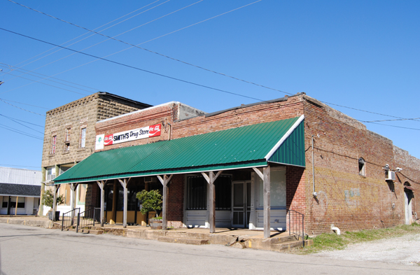
Smith's Drug Store in Rienzi
Continuing with the map, we made a stop for a few pictures in the small town of Rienzi, established in 1830 and named after an Italian Politician. Though this tiny village continues to boast a population of about 300 souls, Rienzi's heydays have obviously faded, as its businesses are mostly gone, and the structures that once housed them sit abandoned, providing for a number of "ghost town" photo opportunities.

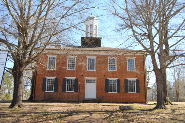
The historic Jacinto courthouse
About eight miles east of Rienzi, we stopped at Jacinto, once the county seat of Tishomingo County and the cultural center of Northeast Mississippi. It was once lined with numerous taverns, businesses, hotels, and even an exclusive boys school. However, when it was bypassed by the railroad in the 1850's, people began to move. After the Civil War, during Reconstruction, Tishomingo County was split into three counties, and the county seat for Tishmingo County was moved to Iuka. Today, Jacinto is a true ghost town. There is very little left other than the historic courthouse.

We then pushed on to Iuka. It was here, in September, 1862 that Confederate General Sterling Price and his men raced to stop Union General William Rosecran's troops just south of town. The battle site appears to cross a major highway; but, there is small Confederate cemetery where 263 of Price's men were buried in a mass grave. Iuka also provides a couple of other historic views at its Mineral Springs Park and the Old Tishomingo County Courthouse and Museum.


Natchez Trace and Shiloh

After our brief stop in Iuka, we broke away from our Civil War map and headed across the state line on Lee Highway (72) into Alabama to get on the Natchez Trace Parkway. We'll be writing a lot about the Trace on our Winter Tour, as we will be on and off it for a good part of our trip. The original Natchez Trace dates back thousands of years to the days of the Mississippi Mound builders. Years later, it was utilized by the Choctaw, Chickasaw, and Natchez tribes who called the region home and traveled upon the trail on hunting and trading expeditions. By the time the first European explorer Hernando de Soto came to the region in 1541, the path was well worn and the Mississippi Mound builders were gone.

Buzzard Roost
Right after getting on the Trace off Highway 72 you immediately run into Buzzard Roost Spring. Originally called Buzzard Sleep, the name was changed to Buzzard Roost in 1801 by Levi Colbert, a renowned Chickasaw chief. The spring was a water source for the Colbert house which also served as an inn and stand for travelers on the Old Natchez Trace. Levi also helped his brother George Colbert run the Colbert Ferry and their stands were about 2 hours apart by horseback.

Continuing on the trace a few more miles, we stop at the site of what was once Colbert's Ferry, which operated across the Tennessee River from 1800 to 1819 and included a stand, or inn, offering travelers a warm meal and shelter during their journey. Looking after their own best interests, the brothers once allegedly charged Andrew Jackson $75,000 to ferry his Tennessee Army across the river. Here, and at about 20 other stands along the Trace, Kaintuck riverboatmen, money-laden businessmen, Indians and outlaws shared a spot of fellowship on a long hazardous road. Today, a beautiful bridge crosses the Tennessee River. This stop includes picnic tables, restrooms, and a boat launch. In fact, despite a chill in the air, a family was having a picnic on the grassy hill overlooking the river when we stopped there.

After crossing the General John Coffee memorial bridge, we came to our first glimpse of an original piece of the historic path. At "Sunken Trace", the trail became so water logged that wagons could not be pulled through, travelers cut new paths through the nearby woods. Here you will see three cuts made to avoid mud into which oxcarts and wagons sank, making progress slow, dangerous and even impossible.  Very visible today, we stood in the trail imagining a time long ago as travelers past through these woods.

Shiloh National Military Park


After crossing into Tennessee we exited off the Natchez Trace and headed west for Shiloh National Military Park. Also called the Battle of Pittsburg Landing, this battle took place in Hardin County, Tennessee in April 1862. As a result of the fall of Forts Henry and Donelson, Confederate General Albert Sidney Johnston, the commander in the area, was forced to fall back, giving up Kentucky and much of West and Middle Tennessee. He chose Corinth as the staging area for an offensive against General Ulysses S. Grant and his Army of the Tennessee before the Army of the Ohio, under Major General Don Carlos Buell, could join it. The Confederate retrenchment was a surprise to the Union forces, and it took Grant, with about 40,000 men, some time to mount a southern offensive, along the Tennessee River, toward Pittsburg Landing. Grant received orders to await Buell's Army of the Ohio at Pittsburg Landing.

Attacking the Union troops on the morning of April 6th, the Confederates surprised them, routing many. However, a number of other Federals made determined stands and by afternoon, they had established a battle line at the sunken road, known as the Hornets Nest. Repeated Rebel attacks failed to carry the Hornets Nest, but massed artillery helped to turn the tide as Confederates surrounded the Union troops and captured, killed, or wounded most of them. Johnston had been mortally wounded earlier and his second in command, General P.G.T. Beauregard, took over.

The Union troops established another line covering Pittsburg Landing, anchored with artillery and were augmented by Buell's men who began to arrive and take up positions. Fighting continued until after dark, but the Federals held. By the next morning, the combined Federal forces were some 40,000 strong, outnumbering Beauregard's army of less than 30,000. Beauregard was unaware of the arrival of Buell's army and launched a counterattack in response to a two-mile advance by General William Nelson's division of Buell's army at 6:00 am, which was, at first, successful. Union troops stiffened and began forcing the Confederates back. Beauregard ordered a counterattack, which stopped the Union advance but did not break its battle line. At this point, Beauregard realized that he could not win and, having suffered too many casualties, he retired from the field and headed back to Corinth. Resulting in a Union victory, the estimated casualties (those wounded, killed or missing) were 13,047 Union and 10,699 Confederate. It was the bloodiest battle of the Civil War to that date.

The Union Siege of Corinth would happen just weeks later and Federal forces would take control of the town, and keep control despite the Confederate push later in the fall. During the war years, around 200 top Confederate and Union Generals were stationed in and around Corinth. At least 300,000 troops were in or around the city during the course of the War, making it the largest aggregate number of troops ever assembled in the Western Hemisphere.

These were also the last major Confederate offensives in Mississippi, and the Union Victories enabled General, and later President, Ulysses S. Grant to put his efforts toward his ninth month campaign against Vicksburg.  Union troops continued using the town of Corinth as a base for raids into Northern Mississippi, Tennessee and Alabama before finally leaving in January of 1864.  Although Confederates would return to Corinth, the end of the war in Mississippi came just a few short months later.

For those who want to learn and understand the costs, human and otherwise, of the Civil War, much can be gleamed from a visit to Corinth and Shiloh.  Both the interpretive center in Corinth, and the Shiloh National Military Park were free of charge to enter, both had driving tours, and we give the overall history experience here 10 Stars for excellence.

Here's our Corinth Area Photo Gallery 

Here's the Slideshow from the Gallery


_____________________________________________________________

RV Park Reviews 

Ozark Mountain Springs RV Park - Mountain View, Mo - We found the manager on site to be very friendly and helpful. Guided us to our spot and made sure we were aware of the amenities. Only stayed one night. Clean and well kept. Accepts Passport members so we were very happy with the rates. Wifi available, full hookups, pull through sites, shade trees, and pet friendly.  We will keep this one in mind for sure on our treks back and forth to the Southeast.  We gave this one 7 out of 10 stars.

Corinth RV Park - Corinth, Ms - About 4 miles out of town. Full hookups and some pull through concrete slabs for parking, although we still had to level side to side. Nice and quiet setting while we were there.  Park is part of a gun club which is closed in winter months (when we visited), so all was good. No other amenities. No on-site management, honor pay system (OK with us). Would not visit during gun club activity (March-October) with regular shoots on Thursday nights. Water  leaked bad enough to submerge the faucet hookup, did not even attempt to use sewer as water was visible in the pipe. Would not stay here at full price of $30/night (Passport rate $15).  We gave this one 6 out of 10 stars in our online review, but should have waited until we left after discovering sewer and water issues. So our rating is actually 5 out of 10.

We are using a 22' Travel Trailer. Electric at least 30 amp or more unless noted.