Wednesday, February 13, 2013

To French Camp on the Trace

We headed South out of Corinth, Ms ready for more journey on the Natchez Trace, picking it back up off highway 30 near Bay Springs Lake. This would be our first day of experiencing the Indian Mounds Kathy has already written about.  Our first stop was Pharr Mounds.  It's the largest and most important archaeological site in northern Mississippi, with eight burial mounds built during the Middle Woodland period, between 1 and 200 A.D. Ranging in height from two to 18 feet, the mounds are distributed over an area of about 90 acres. They comprise one of the largest Middle Woodland ceremonial sites in the southeastern United States.
Pharr Mounds Site

Four of the mounds were excavated in 1966 by the National Park Service. The mounds covered various internal features, including fire pits and low, clay platforms. Cremated and unburned human remains were found in and near these mounds, as were various ceremonial artifacts, including copper spools and other copper objects, decorated ceramic vessels, lumps of galena (shiny lead ore), a sheet of mica, and a greenstone platform pipe.

The copper, galena, mica and greenstone did not originate in Mississippi; they were imported long distances through extensive trade networks. Such ritually significant non-local items typify the Middle Woodland period. The site is located on the Natchez Trace Parkway (milepost 286.7), about 23 miles northeast of Tupelo.

13 Unknown Soldiers

After Pharr Mounds we stopped at another 'sunken trace' site, where the original Natchez Trace was traveled hundreds of years ago.  This stop (milepost 269.4) was different though, as the Civil War had left its mark.  Although the Old Trace had been abandoned by the start of the war, soldiers marched, camped and fought along portions of the historic road.  At this location, you can see the grave sites of 13 unknown soldiers.  The marker near the graves indicates no one really knows who they are or how they died.  But tradition holds that they belong to Confederate Soldiers who camped along this stretch, and either died from their wounds, or the lingering hunger, poverty an sickness in the army camps.
Confederate Grave

Today, their simple grave markers face backwards toward the Trace so that travelers might read and remember.  And many apparently still do.  We found coins laid on the top of the grave stones, as well as flowers and flags by each.  It was another reminder of the horrible sacrifice thousands of American's paid as our country was ripped apart by the Civil War.
Exhibit inside the Parkway Headquarters

Before we exited off the Trace at Tupelo, we visited the Parkway Visitors Center (mile post 266).  This is the Natchez Trace Parkway Headquarters and well worth the stop.  Exhibits about the history of the area, the Trace and it's origins, as well as how it became a National Parkway are all here, as well as a friendly staff ready to answer questions on most anything related to the Trace.  We even got some tips on Natchez, Ms for our upcoming visit to the historic city.  

It was a somewhat short travel day for us, and we wanted to find a place to land for a few days to catch up with our on-line stuff, so we went into Tupelo and found a beautiful RV Park just on the outskirts of town. Unfortunately beauty wasn't what we were after, we just wanted some solid Wifi time.  Despite the RV Parks best attempt at providing Wifi throughout the complex, we had problems connecting, so only spent one night. 

(Note: Related RV Park Reviews at the end of this article) 
The King - Elvis Presley

Although we didn't do Tupelo, there is lots to see and do here. While Tupelo may be the most famous for being the birth place of Elvis Presley, it's also home to the largest antique car collection east of the Mississippi River at the Tupelo Automobile Museum. In addition, according to the Mississippi Official Tour Guide, Tupelo Buffalo Park has one of the largest herds in the east, as well as other exotics, and one of the best petting zoos in the area. 

Being right next to the Natchez Trace Parkway,  as well as having plenty of family entertainment, Tupelo is a great stop for any traveler.  If we had a different agenda on this trip we probably would have visited the Elvis Presley Birthplace and Museum.  It includes the home that Elvis' father built, an Elvis statue with his first guitar, memorial chapel, a park, story wall,  gift shop and more on newly expanded grounds.  

Tupelo Automobile Museum
photographer unknown
Other attractions include the GumTree Museum of Art, a cultural and artistic guide to Tupelo; Lyric Theatre, a turn of the century production theater home now to Tupelo's Community Theatre and promoted as one of the finest live stage facilities in the state; HealthWorks!, a fun new children's health education center with exhibits designed to inspire a lifetime of healthier habits;  and the Mississippi Hills Exhibit Center, which educates visitors about the Mississippi Hills National Heritage area, covering a 30-acre region whose culture is heavily influenced by the intersection of the Appalachian region and the Mississippi Delta. 

Of course, the Civil War also touched this area, with two of the final battles of Mississippi, Brice's Crossroads, and the Battle of Harrisburg nearby.  The Tupelo National Battlefield, a one-acre monument on Main Street in Tupelo, is the site of the July 14, 1864 battle of Tupelo, when Union Troops, including Colored regiments, marched into Tupelo and met an unorganized Confederate force. Involving over 20,000 men, neither side would be able to claim victory, however, the Union achieved its goal of keeping the Confederates away from Union railroads in Tennessee.  The battle would rage until the afternoon of July 15.  Notably, this would be the last time Confederate General Nathan Bedford Forest's famed cavalry troops would fight the Union, and Forest himself was injured and taken out of action for up to 3 weeks. 

Back on the Trace at Tupelo to French Camp

We were back on the Trace sooner than expected on a hunt for an RV Park with adequate Wifi, so we headed south toward French Camp, where we planned to divert off the Trace to Louisville, Ms.  We missed the Chickasaw Village site (milepost 261.8), which has some exhibits portraying the daily life and history at a village that once stood there.  It features a self-guiding trail as well. 

However, we did stop at the site of the Chickasaw Council House (milepost 251.1).  Only a marker along the Trace nearby its original location, the Council House was in the village of Pontatock, which in the 1820s became the Capitol of the Chickasaw Nation.  Chiefs and other leaders met here to sign treaties or establish tribal laws and policies.  Each summer two or three thousand Indians camped nearby to receive the annual payments for lands they had sold to the Federal Government.  The Treaty of 1832 would see the last land surrendered though, and the Chickasaw Council House disappeared. The Chickasaw tribe moved west to Oklahoma where they remain today. 

Marker for the former site of
Tockshish on the Natchez Trace
Just a couple miles south (milepost 249.6) is the marker for Tockshish.  Named for a Chickasaw word meaning "tree root", Tockshish was a mixed community of Native Americans and white men. British agent to the Choctaws John McIntosh first settled here in 1770.  In 1801, McIntosh's place was made the second post office on the Trace as a midway point between Nashville and Natchez, and a relay station where post riders exchanged weary horses for fresh ones. 

Monroe Mission Station has its own marker (milepost 245.6), remembering where the Chickasaws first received Christianity and education in 1822.  By 1827 81 students were attending the school, with boys learning farming and carpentry, and girls learning spinning and weaving in addition to classroom work.  Monroe and three other stations were training centers for many who became leaders of the Chickasaw Nation in Oklahoma. 
Hernando de Soto

Also near here, another two miles south (milepost 243.3) Spanish Explorer Hernando de Soto crossed the animal paths that later became the Natchez Trace. In 1539 he set out on a journey that would take him across the Southeastern US.  In 1540 near this marker he spent the winter among the nearby Chickasaw Natives. After a dispute with the Indians, de Soto and his army moved westward. 

You can read more about Hernando de Soto HERE. 

Another couple of miles south (milepost 241.4) is a marker for the Chickasaw Agency.  These were all important United States agents who lived here from 1802 to 1825 along the trace. The fact that Americans could peacefully travel the road through Indian lands was due in large measure to the agents.  Their efforts to preserve harmony included collecting debts, recovering stolen horses, removing trespassers, and capturing fugitives. Although Winters were lonely for the agents, during the summer months "Kaintucks" on their long journey from Natchez to their Ohio Valley homes would travel the Trace by the thousands.  Many of them expected the agency to supply medicine or food and a good night's rest. 

Witch Dance
While these markers were good to stop at and read, we were ready for a more substantial stop and got one down the road at "Witch Dance" (milepost 233.2).  This site has restrooms, horse trail access, a bike-only primitive campground, and picnicking, but our focus was the haunted aspect.  Already steeped in Native American lore, witches later began to gather at the place for nighttime ceremonies. Celebrating and improving their "abilities", they would feast and dance throughout the night. Legend has it that where their feet touched the ground during their dances, the grass would wither and die, never to grow again. 
Bare spots at Witch Dance

The Chickasaw and the Choctaw Indians in the area immediately began to avoid the scorched patches of ground. During the War of 1812 and the Creek War that followed, Andrew Jackson often traveled up and down the Natchez Trace. Though there is no indication that he feared the spots, they were interesting enough that he recorded them in his journal. 

Read about the Native American Lore and Legends of Witch Dance on the Trace HERE. 

Another mile south (milepost 232.4) is Bynum Mounds.  Built between 2,100 and 1,800 years ago, the six burial mounds range in height from five to 14 feet. Five of them were excavated by the National Park Service in the late 1940s. The two largest mounds have been restored for public viewing. Mound A, the southernmost of the two restored mounds, contained the remains of a woman placed between two parallel burned oak logs at the mound's base. Three additional sets of human remains were also found, consisting of the cremated traces of two adults and a child. 


Bynum Mounds
Mound B, the largest at the site, covered a log-lined crematory pit. An L-shaped row of 29 polished greenstone celts (axe heads) and the cremated and unburned remains of several individuals were located on the ash-covered floor. Other artifacts found in ceremonial context included copper spools, 19 chert projectile points imported from Illinois, and a piece of galena (shiny lead ore). Greenstone, copper, and galena, like the distinctive projectile points, do not originate in Mississippi. These high-prestige goods, like those found at the Pharr Mounds, were imported through long-distance trade networks.

You can read more about the Mississippi Mound Builders HERE.

Line Creek (mile post 213.3) is the former boundary between the Chickasaw and Choctaw Tribes. Unlike many Indian nations who seldom recognized boundaries to their lands, the Chickasaw and Choctaw came to accept this stream as the dividing line between them, and it remained so until both tribes were moved to Oklahoma in the 1830's. Near this marker, Noah Wall and his Choctaw wife had a stand where food and shelter were provided to travelers along the Trace.  
Pigeon Roost (mile post 203.5) is where Nathaniel and David Folsom ran Folsom's stand and trading post, and where millions of passenger pigeons, now extinct, roosted here. 


Driving through the Tornado ravaged
area of the Natchez Trace.
Shortly after that stop we came out of the beauty of the Trace to what appeared to be a nightmarish landscape.  On April 27, 2011, three sections of the Trace Parkway were impacted by a series of tornado's. While two of the sections were less than a mile in length, between mileposts 204 and 212 is an eight mile stretch of destruction.  Pictures can only elude to the devastation, and we were left in awe of Mother Natures force while driving through here. 
The April 2011 Tornado's left miles
of destruction on the Trace.

According to the National Park Service, while they did remove all the downed and damaged trees from the immediate roadway, they left the rest to provide food and habitat for the many animals that call the Parkway home.  "By allowing nature to take its course, visitors can see firsthand the ecosystem's resiliency in response to dynamic forces" the NPS website states. "As you visit the Parkway in the years to come, you will notice subtle changes that demonstrate the natural processes that are constantly going on around us. As time passes, the downed trees will decompose, providing nutrients to the soil for the next generation of growth. In time, nature will reclaim this area."  Until then however, this area is a big reminder of how powerful weather can be, and how much you should pay attention to your surroundings while visiting any National Park.   While there were thousands of people on the Natchez Trace that day in 2011, only one person perished in the storms that hit here.  Unfortunately that was not the case across the state of Mississippi and other parts of the Southeast. 
Original part of the Trace

After we emerged from the tornado stricken area we ran into more "Old Trace" (original part of the historic road at mile post 198.6) and Jeff Busby picnick area and campground (mile post 193.1).  Named for Mississippi U.S. Congressman Jeff Busby, who in 1934 introduced a bill authorizing a survey of the Old Natchez Trace, which just four years later became a unit of the National Park System, this is a great stop for camping, including an RV Campground.  


View from the top of Little Mountain
While we didn't stay, we did take the time to drive up to Little Mountain, one of the highest points in Mississippi (we chuckled when we found out we were at 603 feet above sea level. Especially since places we've lived in Kansas are higher than that).  On a clear day you can see about 20 miles from the top.  It should also be noted here that at one time, this stop on the Trace was home to the only spot right on the Parkway where you could purchase gas, however the station is now closed permanently. 


French Camp Historical Area
After our jaunt to the top of Little Mountain, we headed on down for our final exploration of the day.  French Camp (mile post 180.7) was established around 1810.  Originally known as "Frenchman's Camp" it was founded as a stand  by Louis LeFleur.  Here you can pay a visit to the historic village that includes the Council House Cafe and Carriage House.  A self guided tour around the boardwalk winds through the historic buildings and out cabins.  Local volunteers also run the Alumni Museum nearby.  LeFleur's stand became a school in 1822 and is still in operation today as a Christian boarding school and home for youth facing difficult times. 

You can see our updated story, with mile by mile points of interest along the Natchez Trace Parkway HERE. 

We didn't get back on the Trace at French Camp, instead heading off toward Louisville, Ms where we would park the Trailer and catch up on things.  Found a very nice RV Camp Ground and more just outside of Louisville at Lake Tiak-O'Khata Resort and planted ourselves for a few days.  One thing about traveling like this in an RV and running your business from it at the same time...our pace is our own.  

Next up, we head to the historic area around Jackson and Vicksburg.  In the meantime, enjoy the slide show from the Natchez Trace, or visit the Winter History Tour Gallery "Natchez Trace" HERE. 


primary information sources - National Park Service

_______________________________________________

RV Park Reviews 

Campground at Barnes Crossing - Tupelo, Ms - Just as you enter Tupelo after exiting the Natchez Trace. Reserved and paid two nights due to advertising that Wi-Fi was available at all campsites. Unfortunately Wi-Fi did not work hardly at all while we were there. Pull through site was uneven and a little difficult to get into due to concrete retaining wall on one side. Nicely landscaped, beautiful campground with tiered levels, very close to shopping and services. Full Hookups and Cable TV.  Left after one night and received refund for second night without a problem due to our immediate needs for Wifi. Not a Passport campground, rate $32 a night.  We gave this one 6 out of 10.

Lake Tiak-O'Khata Resort - Louisville, MS - This site was more than adequate for our purposes, which was to catch up on work.  For leisure travelers it's even better. Lake front spots  available, full hookups, level slabs, cable, and Wifi.  Wifi could be iffy in some spots, but talk to management and they will guide you accordingly.  Rates were good ($20 per night).  Cable was good, however HD channels iffy.  Had to dig through leaves a bit to find the water and sewer hookups, but tis the season.  Roads were a little rough coming in and could use some maintenance.  Pet friendly.  Would stay here again. We gave it an 8 out of 10 rating, although some reviewers noted problems negotiating into their spots (probably longer trailers). 

(Note: We use RV Park Reviews. Traveling in a 22' Travel Trailer. All electric 30 amp or more unless otherwise noted). 

Thursday, February 07, 2013

Corinth, Shiloh and the Natchez Trace

Planned Route
Our Winter History Tour started off with a sputter. After our departure from the home office in Warsaw Missouri was delayed by severe weather, we finally made it to our first destination a day or two later than anticipated. After making a one night stop at a pleasant little campground in Mountain View, Missouri we made our way to Corinth, Mississippi. This was our first "long term" RV Park stay of the trip (about five days), as there is plenty of history to see in the area. We did our best to ignore the cold, and somehow the weather fit our mission. I think many of us, regardless if it were 100 degrees, would get a cold chill when learning about the humbling history here that claimed so many thousands of lives. (Note: RV Park reviews at the end of this article).

The railroad crossroads
are still used today.
In 1854, the citizens of what was then, Tishomingo County invited two railroad companies to build lines through the largely agricultural area of Northern Mississippi. The Mobile & Ohio, and the Memphis & Charleston railroads soon started construction with their two routes intersecting in the North Central part of the county. "Cross City" grew up at this crossroads and soon changed its name to Corinth.

By 1860, the town boasted 1500 residents and was on its way to becoming a prominent town, with several fine homes, hotels, churches and even a school for young women, Corona College. However, when the Civil War began in 1861, both sides recognized the importance of Corinth due to the cross roads of two major rail lines. That set the stage for two significant engagements, a Union siege of the town after taking control of the Tennessee River at the Battle of Shiloh, Tennessee in the spring of 1862, and a most bloody conflict later in the fall as Confederates failed to take back the town.
Contraband Camp
There's lots to see for history buffs with dozens of historic sites in and around Corinth. Check out the Contraband Camp, which was established after the Union took control, and allowed former slaves, now refugees, a place of safety behind Union lines. This would be an important place for African Americans as it was the first step on the road of freedom and the struggle for equality.

Corinth Civil War Interpretive Center
Don't miss the Corinth Civil War Interpretive Center, a division of the Shiloh National Military Park, open every day 8-5 except Christmas. Exhibits include interactive displays and multimedia presentations on the Battle of Shiloh and the Siege of Corinth. The culminating interpretive feature is a commemorative courtyard where stone and flowing water chronicle the birth and growth of the United States, the accompanying rise of sectionalism, key events leading to the Civil War, and a symbolic representation of four years of war. We found the Interpretive Center to be an excellent experience. A must stop on any visit to Corinth.

Read our full article on "The Siege, Battle, History & Attractions of Corinth" HERE.

Crossroads Museum
Also see the Crossroads Museum, where the two critical rail lines meet, and the Black History Museum, featuring a vast permanent collection documenting black history in Corinth and Alcorn County. Corinth also has a bit of aviation history, as, in 1910, Ernest Waits built and flew one of the first "aeroplanes" in the south. Aviation pioneer Roscoe Turner was born in Corinth. And, as recent as 2000, Corinth native, Gus McCleod, was the first person to fly around the North Pole in an open cockpit plane. Other notable figures include Cartoonist, Russell Keaton. Today, Corinth is called home to just under 15,000 people and features plenty of dining and shopping opportunities, including it's historic downtown, as the city boasts "History is only half our story."

Around Corinth

After seeing the city, we took a full day circle trip, first heading south of Corinth, then northeast to Alabama and Tennessee on the Natchez Trace Parkway, westward to Shiloh National Military Park, and back to Corinth. This was a fun excursion, as it involved plenty of back roads to lessor known places. Following a map we picked up at the Interpretive Center called "A Guide to the Corinth Campaigns of 1862" we headed south of Corinth along the old roads to Rienzi and Jacinto. Our first stop was to be Union Camp Davies, but, either we were clueless, the map wasn't accurate, or they didn't have it marked, as we could never find it.
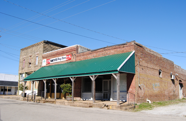
Smith's Drug Store in Rienzi
Continuing with the map, we made a stop for a few pictures in the small town of Rienzi, established in 1830 and named after an Italian Politician. Though this tiny village continues to boast a population of about 300 souls, Rienzi's heydays have obviously faded, as its businesses are mostly gone, and the structures that once housed them sit abandoned, providing for a number of "ghost town" photo opportunities.

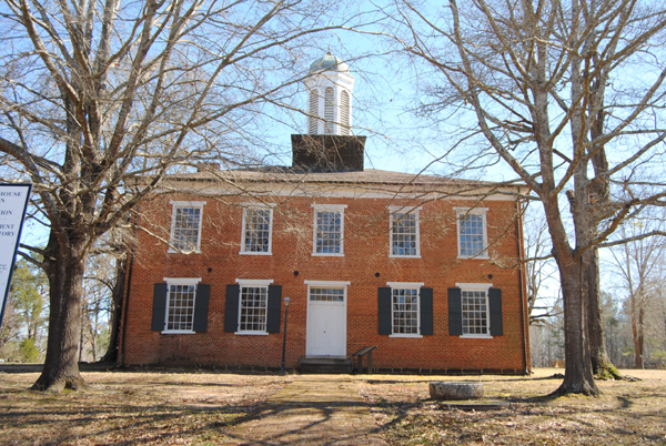
The historic Jacinto courthouse
About eight miles east of Rienzi, we stopped at Jacinto, once the county seat of Tishomingo County and the cultural center of Northeast Mississippi. It was once lined with numerous taverns, businesses, hotels, and even an exclusive boys school. However, when it was bypassed by the railroad in the 1850's, people began to move. After the Civil War, during Reconstruction, Tishomingo County was split into three counties, and the county seat for Tishmingo County was moved to Iuka. Today, Jacinto is a true ghost town. There is very little left other than the historic courthouse.

We then pushed on to Iuka. It was here, in September, 1862 that Confederate General Sterling Price and his men raced to stop Union General William Rosecran's troops just south of town. The battle site appears to cross a major highway; but, there is small Confederate cemetery where 263 of Price's men were buried in a mass grave. Iuka also provides a couple of other historic views at its Mineral Springs Park and the Old Tishomingo County Courthouse and Museum.


Natchez Trace and Shiloh

After our brief stop in Iuka, we broke away from our Civil War map and headed across the state line on Lee Highway (72) into Alabama to get on the Natchez Trace Parkway. We'll be writing a lot about the Trace on our Winter Tour, as we will be on and off it for a good part of our trip. The original Natchez Trace dates back thousands of years to the days of the Mississippi Mound builders. Years later, it was utilized by the Choctaw, Chickasaw, and Natchez tribes who called the region home and traveled upon the trail on hunting and trading expeditions. By the time the first European explorer Hernando de Soto came to the region in 1541, the path was well worn and the Mississippi Mound builders were gone.

Buzzard Roost
Right after getting on the Trace off Highway 72 you immediately run into Buzzard Roost Spring. Originally called Buzzard Sleep, the name was changed to Buzzard Roost in 1801 by Levi Colbert, a renowned Chickasaw chief. The spring was a water source for the Colbert house which also served as an inn and stand for travelers on the Old Natchez Trace. Levi also helped his brother George Colbert run the Colbert Ferry and their stands were about 2 hours apart by horseback.

Continuing on the trace a few more miles, we stop at the site of what was once Colbert's Ferry, which operated across the Tennessee River from 1800 to 1819 and included a stand, or inn, offering travelers a warm meal and shelter during their journey. Looking after their own best interests, the brothers once allegedly charged Andrew Jackson $75,000 to ferry his Tennessee Army across the river. Here, and at about 20 other stands along the Trace, Kaintuck riverboatmen, money-laden businessmen, Indians and outlaws shared a spot of fellowship on a long hazardous road. Today, a beautiful bridge crosses the Tennessee River. This stop includes picnic tables, restrooms, and a boat launch. In fact, despite a chill in the air, a family was having a picnic on the grassy hill overlooking the river when we stopped there.

After crossing the General John Coffee memorial bridge, we came to our first glimpse of an original piece of the historic path. At "Sunken Trace", the trail became so water logged that wagons could not be pulled through, travelers cut new paths through the nearby woods. Here you will see three cuts made to avoid mud into which oxcarts and wagons sank, making progress slow, dangerous and even impossible.  Very visible today, we stood in the trail imagining a time long ago as travelers past through these woods.

Shiloh National Military Park


After crossing into Tennessee we exited off the Natchez Trace and headed west for Shiloh National Military Park. Also called the Battle of Pittsburg Landing, this battle took place in Hardin County, Tennessee in April 1862. As a result of the fall of Forts Henry and Donelson, Confederate General Albert Sidney Johnston, the commander in the area, was forced to fall back, giving up Kentucky and much of West and Middle Tennessee. He chose Corinth as the staging area for an offensive against General Ulysses S. Grant and his Army of the Tennessee before the Army of the Ohio, under Major General Don Carlos Buell, could join it. The Confederate retrenchment was a surprise to the Union forces, and it took Grant, with about 40,000 men, some time to mount a southern offensive, along the Tennessee River, toward Pittsburg Landing. Grant received orders to await Buell's Army of the Ohio at Pittsburg Landing.

Attacking the Union troops on the morning of April 6th, the Confederates surprised them, routing many. However, a number of other Federals made determined stands and by afternoon, they had established a battle line at the sunken road, known as the Hornets Nest. Repeated Rebel attacks failed to carry the Hornets Nest, but massed artillery helped to turn the tide as Confederates surrounded the Union troops and captured, killed, or wounded most of them. Johnston had been mortally wounded earlier and his second in command, General P.G.T. Beauregard, took over.

The Union troops established another line covering Pittsburg Landing, anchored with artillery and were augmented by Buell's men who began to arrive and take up positions. Fighting continued until after dark, but the Federals held. By the next morning, the combined Federal forces were some 40,000 strong, outnumbering Beauregard's army of less than 30,000. Beauregard was unaware of the arrival of Buell's army and launched a counterattack in response to a two-mile advance by General William Nelson's division of Buell's army at 6:00 am, which was, at first, successful. Union troops stiffened and began forcing the Confederates back. Beauregard ordered a counterattack, which stopped the Union advance but did not break its battle line. At this point, Beauregard realized that he could not win and, having suffered too many casualties, he retired from the field and headed back to Corinth. Resulting in a Union victory, the estimated casualties (those wounded, killed or missing) were 13,047 Union and 10,699 Confederate. It was the bloodiest battle of the Civil War to that date.

The Union Siege of Corinth would happen just weeks later and Federal forces would take control of the town, and keep control despite the Confederate push later in the fall. During the war years, around 200 top Confederate and Union Generals were stationed in and around Corinth. At least 300,000 troops were in or around the city during the course of the War, making it the largest aggregate number of troops ever assembled in the Western Hemisphere.

These were also the last major Confederate offensives in Mississippi, and the Union Victories enabled General, and later President, Ulysses S. Grant to put his efforts toward his ninth month campaign against Vicksburg.  Union troops continued using the town of Corinth as a base for raids into Northern Mississippi, Tennessee and Alabama before finally leaving in January of 1864.  Although Confederates would return to Corinth, the end of the war in Mississippi came just a few short months later.

For those who want to learn and understand the costs, human and otherwise, of the Civil War, much can be gleamed from a visit to Corinth and Shiloh.  Both the interpretive center in Corinth, and the Shiloh National Military Park were free of charge to enter, both had driving tours, and we give the overall history experience here 10 Stars for excellence.

Here's our Corinth Area Photo Gallery 

Here's the Slideshow from the Gallery


_____________________________________________________________

RV Park Reviews 

Ozark Mountain Springs RV Park - Mountain View, Mo - We found the manager on site to be very friendly and helpful. Guided us to our spot and made sure we were aware of the amenities. Only stayed one night. Clean and well kept. Accepts Passport members so we were very happy with the rates. Wifi available, full hookups, pull through sites, shade trees, and pet friendly.  We will keep this one in mind for sure on our treks back and forth to the Southeast.  We gave this one 7 out of 10 stars.

Corinth RV Park - Corinth, Ms - About 4 miles out of town. Full hookups and some pull through concrete slabs for parking, although we still had to level side to side. Nice and quiet setting while we were there.  Park is part of a gun club which is closed in winter months (when we visited), so all was good. No other amenities. No on-site management, honor pay system (OK with us). Would not visit during gun club activity (March-October) with regular shoots on Thursday nights. Water  leaked bad enough to submerge the faucet hookup, did not even attempt to use sewer as water was visible in the pipe. Would not stay here at full price of $30/night (Passport rate $15).  We gave this one 6 out of 10 stars in our online review, but should have waited until we left after discovering sewer and water issues. So our rating is actually 5 out of 10.

We are using a 22' Travel Trailer. Electric at least 30 amp or more unless noted.


Friday, January 25, 2013

South Bound


Legends' Mobile Motel
We're getting ready for our annual extended winter trip. This year we are headed to Mississippi, Louisiana, with just a little slice of southeast Texas. Many of you on our Facebook FanPage indicated that you would like to see our itinerary and, as we travel, to provide our impressions and reviews of the places that we visit.

This blog is the place for both. Legends of America is our fact and information website, while Legends' Blog is where we post information as we travel, updates for our readers, and any personal thoughts. When we're on the road, most nights we will review our photos and the information on the places that we've visited, then begin to share it with you here. While we have not always, in the past, provided our first impression and reviews, we will begin to do so on this trip.

So, you see everything on the blog first, sometimes months before it ever appears on  Legends of America. Those tales often take a lot of research and tend to take off on many other paths.
Planned Route
Plans are to leave sometime next week. We've got to ensure that all is good with the "mobile motel" and also tie up some loose ends on the business side. We plan to take two days to get to Mississippi, over-nighting at a campground in southeast Missouri. Our first destination is Corinth. From there, we head across the Magnolia State via the Natchez Trace  then to New Orleans, southern Louisiana, and a small slice of southeast Texas before heading north and making our way home via Arkansas. 

That's all assuming that the weather cooperates. Dave, the resident weatherman in the family, is saying that while Mississippi and Louisiana had higher than average temperatures for January, there is an expected change in the gulf stream for the month of February, making it colder than average. Depending on how cold it gets and other weather conditions, such as rain, ice or snow, it would not be unlike us to abandon plans on a few hours notice and head in another direction. But, until and if, here are the plans for the trip.

When we travel for weeks at a time, we operate on what we call a "hub and spoke" schedule. That means, we find a campground, drop the travel trailer, and make day trips to surrounding areas for several days. The schedule is aggressive -- I load it up in order not to miss anything; but, depending on how time goes, can't guarantee we will make every stop.

Battle of Corinth
Corinth, Mississippi Area:
Natchez Trace
Jackson, Mississippi Area:
Ruins of Windsor
Natchez, Mississippi Area
Tchefuncte River Light House
Southeast Louisiana:
Mississippi Coast Line
Mississippi/Louisiana Coast:
Lafayette, Louisiana Area:

Sabine Pass Battleground
Southwest Lousiana and Southeast Texas:
Central Louisiana:
Natchitoches
Natchitoches, LA and East Texas:
Nacogdoches
Nacogdoches, Texas Area:
The remainder of route will be determined by time available. Choices are to continue through Texas for a family visit near Sherman, checking out several ghost towns along the way, and heading northeast Arkansas through Little Rock and Scenic 7 Byway to Missouri . Alternatively, we'll skip the rest of Texas and head home -- hopefully along the same Arkansas route. 

Whew!!! I'm tired just writing all this down. It's gonna be a whirlwind trip - estimating about 6 weeks. If I've missed important historical sites and you're familiar with the area, please let me know.

Otherwise, we'll "see" ya on the road.

Kathy Weiser-Alexander
Owner/Founder, Legends of America

Sunday, January 20, 2013

Change In Name for Our Store


Just a quick house keeping note.  As we move into our 10th year on the world wide web, we have decided it's time to further streamline our overall brand.

Kathy started the "Rocky Mountain General Store" in 1998 as a booth in an antique mall near Warsaw, Mo. In 2003, when Kathy started Legends Of America, she began using the Rocky Mountain General Store as a way to support her hobby. Today, all of our products have moved "On Line", and are the primary funding source for Legends Of America's travels, free news letter, and thousands of pages on American History.

In 2013 we are further incorporating the Rocky Mountain General Store into our primary business, renaming it simply Legends' General Store.

As we always, we continue to offer a variety of history and travel related products, in addition to many other items, and the change is in branding/name only.  You will continue to see the highest level of customer service and quality products you've come to expect from our small business.

Our primary categories of products remain

Our Old West Merchandise


Our Native American Products


Our Route 66 Products 


In addition we have added Outdoor, Sports and Travel and Gift Ideas for additional ease in browsing our store.

For more about Legends' General Store, and our other offerings, see About Us in the store. And stay connected with specials and featured products by liking our stores Facebook page.

Dave Alexander (Owner-Operations Manager)
Kathy Weiser-Alexander (Owner/Founder)
Legends Of America


Monday, November 05, 2012

Jim Hinckley Contributes to Legends

Author Jim Hinckley
Legends Of America is proud to announce that award winning author Jim Hinckley is now an official contributor to our website.  Many are already familiar with Jim's fantastic works, including books on Route 66 and Ghost Towns. Jim is also known in the auto world as a former Associate Editor of Cars and Parts Magazine, where he contributed a monthly column profiling the independent thinkers of the American Auto industry.

His love of history, especially that of Route 66 and the American Southwest, shine bright through his photography and his writings.  Jim says "After years of having friends and associates tell me that I was blessed with a gift for telling folks where to go, and with support from my loving wife, I began writing about my passion for lost highways, the road less traveled, the special places found along the way, and the vintage vehicles that once traveled them."   Eight books have resulted from that passion to date, along with more than a thousand feature articles for a wide array of publications including Old Cars Weekly, Classic Auto Restorer, American Road and others.  Jim was also featured in an interview with Jay Leno on Jay Leno's Garage.

In 2010, Jim was one of several Co-Authors, including Legend's founder Kathy Wesier-Alexander, for the book "Greetings From Route 66".  It was during this project we became more familiar with Hinckley's work and began following his adventures.  After several attempts to connect, always interrupted by life on our end, we finally had the chance to sit down with Jim at last months Cuba Missouri Route 66 Festival. Our partnership formed quickly over some bacon, biscuits and gravy.  And who doesn't like bacon?  It was enough for us to know it would be a productive agreement.  Jim blogged "To say I am excited about being a contributor for this website would be a gross understatement as it has been a favorite of mine for years." 

We look forward to bringing you Jim's passion on a regular basis, including two new stories already published.  "Two Heads are Better Than One"  is the story of brothers F.O. and F.E. Stanley, legendary automobile pioneers who transformed the world with their genius.  And "Frontier Era Time Capsule", a look at the Johnson Canyon rail tunnel, an Arizona forgotten time capsule of large importance in American rail westward expansion.

Jim currently writes a blog "Route 66 Chronicles", about the life of a starving artist on Route 66, and says "It is my sincere hope that you find my books and articles an inspiration for over coming obstacles, discovering the joy that comes from seeking the road less traveled, and are inspired to make a road trip or two."

You can read more about Jim on his Legends Bio Page, which also has links to his various books and of course, articles on Legends Of America.

Please help us welcome Jim Hinckley to Legends Of America!