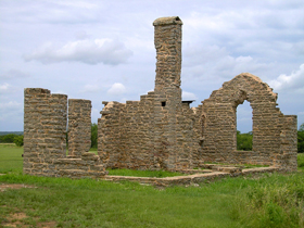
Sunday, November 29, 2009

Texas to Missouri - Finding Our Way Home

We had a wonderful Thanksgiving with family in Pampa Texas and enjoyed another day of down time before heading out on Friday to make our way home. Most of the time when we come see them, we travel I-40, but knowing we weren't going to make the full way home in one day this trip, we decided to spend some quality time in North Central Oklahoma on roads less traveled.

About 20 miles east of the Texas border, and 30 miles north of I-40 near Cheyenne Oklahoma, we found The Washita Battlefield National Historic Site. This is where Lt. Col. George Custer led the 7th US Calvary on a surprise attack at dawn against a Southern Cheyenne village and the tragic slaughter of it's people. The attack was just a day after their leader, Chief Black Kettle, had returned from peace talks with the US. The Peace Chief was killed in the battle, and to this day the area is a reminder of the tragic clash of cultures that took so many lives.


Moving on down highway 283, we found our way to Highway 33 and boogied across Central Oklahoma with not much else on the agenda for that Friday, other than seeing some of the towns we usually miss traveling more major thoroughfares through the state. Like Kingfisher, situated on the Chisholm Trail and founded during the Federal Governments "Land Rush" in the late 1880's. If you make it there, be sure to check out the Chisholm Trail Museum and Governor Seay Mansion.

Eastward still on Highway 33 we pass through Guthrie, home of Oklahoma's first capitol, and across I-35 until finally meeting up with I-44 just outside of Tulsa. Doing this area quite a bit on our Route 66 travels, we decide to push on without stopping to our final destination of the day, Grand Lakes, where good friends await to put us up for the night [Thanks Susy, Jerry and Lou! We had a blast!!..oh, and Randy too for the great suggestions on places to go in South West Missouri :) ]

Coming Home....

Saturday we said goodbye to our friends and began our trek to far Southwest Missouri, winding around Grand Lake, then onto highway 59 through Copeland, eventually meeting up with highway 90 into Noel Missouri. This is one of the few "Christmas" cities in the US, where people send letters to have postmarked for the holiday, and is in McDonald county, which has a strong history of Civil War skirmishes and later became a very popular vacation destination. There were many resorts throughout the county, and touring Caves as well, including the still active Bluff Dwellers Cave near Noel.

Our bonus on this part of the trip though was finding Truitt's Cave on Highway 59 north of Noel in Lanagan Missouri. This once thriving tourist stop still has a billboard on the highway, but is abandoned after traffic found faster ways through the area on the expanded 71 highway nearby. Almost like a Route 66 relic, it fascinated both of us how something that once housed a Cave restaurant, underground wedding chapel and even a trout reservoir could be pushed aside and forgotten. A little research shows that the closing was actually pretty recent in 2004. What made our stop even more special was finding the grand children of one of the previous owners there, walking the grounds with us, reminiscing about their childhoods and just how "neat" the place really was.

Still pushing north, we made our way to Carthage, site of the Battle of Carthage, another one of the notable fights in the Civil War. Carthage has a beautiful downtown and several mansions along an historic drive through the city. It's also historic for it's role on Route 66, and of course Kathy and I could no longer resist the call of the Mother Road and just had to head east toward Springfield to at least take in a small part of it.

Along the route we made a stops at Spencer and at Paris Springs Junction, home of the Gay Parita Sinclair Station. The original building is gone, but Gary Turner and his son Steve rebuilt the 1930's era icon in 2006, and it's a great stop for all Route 66 enthusiasts. Kathy of course was in hog heaven taking pictures of long forgotten stops along the route all the way to Springfield where we finally ran out of daylight, and headed north on 65 to our home base in Warsaw.

It was a 2,200 mile round trip through Arkansas, Oklahoma and Texas, and a memorable one for sure. Thanks for following along. We have no idea where we will go next, but in the meantime we'll continue to write about the incredible stories of the American West with dreams of the road on our horizon. Be watching the "What's New" page for articles born out of our adventure.

Friday, November 27, 2009

The Heart of the Texas Forts Trail

Setting up Abilene as a home base for a couple of days was a good idea, as we had a lot to see in Central Texas on day 5 of our Texas forts tour. We got an early start that morning and headed south on Buffalo Gap road. Buffalo Gap is a small town about 13 miles South West of Abilene founded in 1857. Once a center for Buffalo hunters, you can enjoy the towns Historic Village which still has the original 1879 sandstone jail and courthouse. Plan ahead and be there during normal touring hours though, as we were a bit early and had to take in the sites from outside the fence.

We left there and started back toward highway 83, then through Ballinger, home to "The Cross", a 100 feet tall 50 ton monument that can be scene from miles outside of town. Built in 1993, The Cross is known for it's spectacular views at sunset and is something you won't miss, even if your just driving by.

From Ballinger we continued south on 83 to Paint Rock, where just outside of town you can tour hundreds of Indian Pictographs along a rock bluff overlooking an Indian camp ground. Most of them are thought to be up to 500 years old and maybe even older, and some pottery found at the site has been dated to 1000 years old. Access is possible most days, but preferably by appointment. This is another stop you should plan ahead for, and if you happen to be in the area at the time, go during an Equinox when solar markers appear and are thought to show the ascension of a spirit to the "Happy Hunting Ground". [Note: we didn't plan ahead, and therefore we didn't get to see the rocks this trip :( ]

After Paint Rock, and through Eden, we come to Menard, where in 1757 Spanish authorities built Presidio San Luis de Las Amarillas to protect nearby Mission Santa Cruz de San Saba from Native American raids. This was an interesting stop not only for the history, but for the quirkiness of where it is. When you pull into the site of the Presidio you're pulling into a golf course, complete with a tee box just outside one of the ruins remaining stone windows. Being history buffs we were a bit appalled at the thought that a hacker on the golf course could slice into the ruins, but I guess not everyone see's history the way we do.

Heading west on highway 190 just over 20 miles from Menard is Fort McKavett State Historic Site. Etablished in 1852, the post housed companies of each of the four regiments of Buffalo Soldiers formed after the Civil War. Today you can tour several buildings as the grounds still have 16 historic structures, including the post, headquarters and schoolhouse.

Back onto 190, then north on highway 277, we go through San Angelo, home of Fort Concho. Besides touring the Fort, San Angelo has a lot to do for just about anyone, including a scenic River Walk, historic downtown and even Miss Hattie's Bordello Museum, and early 1900's brothel that operated until 1946 when Texas Rangers finally shut it down. San Angelo also offers a look at the stars in the nations fourth largest university planetarium at Angelo State.

Our final stop on day 5 was Fort Chadbourne between San Angelo and Abilene on 277. The fort is on private land but open to the public and accepting donations for several ongoing projects, including a planned new visitors center adn restoration of the Butterfield Stage Stop. Established in 1852, the fort protected settlers moving through Indian territory. It was a good stop to end our long day as we headed back to the hotel to rest up for our final Texas Fort Trail push.

Day 6 - Abilene to Pampa (Wrapping up the Texas Forts Trail)

Time didn't allow us to do the entire Texas Forts Trail, but we did get a chance to have some fun in Abilene before heading north to the Panhandle. Abilene is home to Frontier Texas, a fantastic museum near downtown that welcomes visitors to experience the sights and sounds of frontier life from 1780 to 1880 through animated video characters. These holographs give you a since of what life was really like and we both felt moved by the stories told. A must stop for the old west adventurer, make sure you see Frontier Texas if you're anywhere near Abilene.

Moving north on the Texas Forts Trail on Farm Market 600 we come to Fort Phantom Hill, another fort on private land, but this one not kept up as well as Fort Chadbourne. Several of the signs in front of old ruins are gone, and none of the buildings remain in tact, but it's still a good stop to see some history. This federal post from 1851 to 1854 experienced only peaceful encounters with Plains Indians during it's brief duty, and later served as a stop on the Butterfield Overland Mail route as a sub-post to Fort Griffin.

Texas Forts now out of our system, we made our way on a long journey north to the Panhandle, wrapping up our day with a final stop at Caprock Canyons State Park. Near Turkey Texas, home of western icon Bob Wills, the canyon offered a beautiful contrast to the rugged Texas plains we had experienced as the Sun began to set on the red canyon walls. If you're a camper or RV'er, this is a good place to spend a couple of days hiking and taking in the scenery.

With the sun rapidly leaving us, we move north to Pampa Texas on highway 70 to spend time with family at "Fort Alexander." Thanks for the vittles mom and dad, and Happy Thanksgiving to all.

Wednesday, November 25, 2009

Howe to Abilene - The Texas Forts Trail

We had a long way to go, and a short time to get there....hmm, haven't I heard that in a song? Either way, we didn't start our travel until after lunch, saying goodbye to family in Howe, Texas, we hit highway 82 out of Sherman to I-35, south to Denton, then highway 380 west to Jacksboro, home of Fort Richardson.

The northernmost post of a line of forts stretching from the Rio Grande to the Red River, Fort Richardson played an important role in conquering the native Plains Indians and forcing them onto reservations north of the Red River. Now a National Historic Lnadmark and Texas State Park, seven original buildings remain and have been restored, along with two replica fort buildings. If you're an RV'er, this park has several nice campsites to take advantage of.

Fort Richardson is also the home of the "Lost Battalion", a group of Texas National Guardsmen who were mobilized at the site during World War II and eventually were captured in Java, spending the rest of the war as prisoners. A historic marker at the park commemorates them today.

From Jacksboro we moved on down 380 to Graham, home of the largest town square in the US, then up FM61 to Fort Belknap, which is now simply a county park. The fort was used mainly as a base of operations and served as a hub for a network of roads, including the Butterfield Overland Mail. Abandoned prior to the Civil War, partly due to a lack of water, portions of the fort have been rebuilt on their original foundations, and it remains a National Historic Landmark.

From Fort Belknap north on FM61, back onto highway 380 to Throckmorton, we start our final trek of the day south on 283 toward Abilene with Fort Griffin on our mind. Late in the day, we didn't get to see all we wanted, but Kathy has actually been here before so we're covered. Little remains standing of this fort, originally named Fort Wilson, but renamed in honor of Major General Charles Griffin of the Texas Army Department, who made the original fort plans. The soldiers at the fort stayed busy keeping the Indians in check during the Red River Campaign which continued through 1874, meanwhile the town that formed nearby had a history of lawlessness as ruffians and outlaws moved in.

Several notable figures of American history are tied to Fort Griffin. Doc Holliday and Wyatt Earp first met there. Gambler Big Nose Kate, lawman Pat Garrett and gunfighter John Wesley Hardin also spent time there.

Traveling from Fort Griffin to Abilene the sun was quickly setting on our day, but not before we got to see an ironic sunset. Well, not sure I should call it ironic, but a horizon dotted with huge wind mills intermingled with Oil Rigs is strange in my books.


We are using Abilene as a home base for a couple of nights. On our next blog, we'll take you south through the true Heart of Texas and back as we continue to explore the Texas Forts Trail. Also be watching our "What's New" page for stories on Fort Richardson and Fort Belknap coming soon.

Tuesday, November 24, 2009

Eureka Springs Arkansas to Howe Texas

Coming out of Eureka Springs we found ourselves north on 62, a windy mountain road that had a special fall feel to it. Fog rising over rivers added to a mystique that lingered over sleepy homes dotting the valley below us. We got off to an early start, partly due to the lack of internet at the hotel the night before, but mainly because we had 300+ miles to cover, and a lot of stops along the way.

First on the agenda was Pea Ridge National Military Park. Touted as the battle that saved Missouri for the Union, this is one of the most intact Civil War battlefields today, and is the only battle in which Native American troops participated. 1000 Cherokees fought for the Confederate army and routed two companies of Union cavalry before being forced into the woods by cannon fire.

Pea Ridge Park also has a very visible portion of the Trail of Tears, also known as Telegraph Road, which thousands of Cherokee and other American Indians traveled in the winter of 1838-39 after being forced to move from their homelands. It also served as the Butterfield Overland Stage Route from 1857-61, and during this key battle in March of 1862, both Federals and Confederates would use it as well.

The auto tour is great, and includes a fantastic view from a hill of the entire battle field. You can almost imagine being there as interpretive signs show positions of various troops and tell the story of how Pea Ridge was the last push of the Confederates to take Missouri, and with their failure how many of the troops, both Union and Confederate, moved on east of the Mississippi to fight in other campaigns.

From Pea Ridge, we continued on highway 62, now heading southwest skirting Fayetteville, Arkansas to Prairie Grove Battlefield State Park. This smaller Civil War battlefield site is also an auto tour, but unlike Wilson's Creek and Pea Ridge, this one lacked a bit. In fact, part of the auto tour took you out of the park, back on 62 and then into a residential area. It's still a great place for history though and I'm glad we had the chance to see it.

We stayed on highway 62, winding our way to Oklahoma and Tahlequah, the Cherokee Nation Capitol. Just outside of Tahlequah is the W.W. Keeler complex, the seat of the tribal government, and we made brief stops at the Cherokee Heritage Center, The Murrell Home built in 1844, and a fairly new Cherokee Warriors Memorial, dedicated in 2005 to those who have fought in the United States Military.

Still on 62, just outside of Muskogee, we reach Fort Gibson, one of the most important posts on the "permanent Indian frontier." Established in 1824, this Fort was a key transportation point and testing hub for the newly activated Ranger units and Dragoon Regiments. It played roles in the Civil War, Mexican-American and Indian Wars, and was long gone by the time it was reconstructed in 1936 under the WPA. Be sure to tour the stockade and other reconstructed outlying buildings, it's worth the stop.

By this time we were running out of daylight. Shorter days mean less sightseeing, so we boogied on down highway 69 from Muskogee to Howe Texas, just south of Sherman, where we would bunk with family for a couple of nights in "Fort Bertoldo" (Thanks Jimmy and Deb!) Be sure to watch the "What's New" page for expanded articles on our adventures. Next blog we travel the Texas Forts Trail from Howe to Abilene.

Monday, November 23, 2009

Warsaw to Eureka Springs

One thing about traveling in November is the lack of color in the scenery. You miss the Spring or Fall colors, and the Summer greens. All the leaves have browned weeks ago, leaving the baron branches of thick forests dormant til next year. But despite that, it's still a beautiful drive in southern Missouri and northwest Arkansas.

We headed out south on Highway 65 toward Springfield and found our first detour just outside of there in Ozark. A quick drive through Ozark's historic downtown, then back across 65 several miles to Wilson's Creek National Battlefield. It's the site of the second battle of the Civil War, and so far off the beaten track I imagined a spot in the road with a sign.

We were pleasantly surprised with the nice Visitors Center, exhibits and even a short movie on the history of the area. The Battle of Wilson's Creek, called Oak Hills by Confederates, was fought August 10, 1861, and was a bitter struggle for control of Missouri in the Civil War's first year. In fact it was only the second battle of the war.

There were heavy losses on both sides, but Missouri stayed in Union control. The easy to follow auto-tour of the battlefield took us through the various aspects of the Battle, and we learned plenty about the state and how it became the third most fought-over in the nation. Be looking for the complete story of this historic battle on our What's New page soon.

Our minds swimming with visions of the Civil War, we headed out of the battlefield and decided to take roads less traveled on to Eureka Springs. After going through portions of the Mark Twain National Forest, we wound up coming into the Springs via Highway 23 and were greeted with the Eureka Springs North American Railway. We're coming into town during the off season, so the railway was closed to tourists, but there was still plenty for the history lover to see, including the Round House Inn across the street that is currently up for sale.

On into town we started to get a better feel for Eureka Springs, with its historic hotels and businesses. That includes two supposedly haunted hotels, The Basin Park Hotel and The Crescent Hotel, both of which offer haunted tours in the evenings. We didn't have time to take the tours, but did visit both hotels and took in the atmosphere of a town already decked out for the holidays. If you plan to visit Eureka Springs be ready to park and walk as the streets of downtown are narrow and there's lots of others taking in the sights with you.

Eureka Springs is also home to The Passion Play, which seemed to be a religious theme park complete with a giant statue of Jesus called Christ of the Ozarks, erected back in 1966. The park even had a piece of the Berlin Wall on display outside of an old Church building on the grounds.

There would be enough to see in Eureka Springs to keep us busy for a couple of days, but our focus on this trip is mainly battlegrounds and forts, so we spent our quiet evening resting up for the next days adventure all the way through the Cherokee Nation of Oklahoma to Howe Texas, with another key Civil War battlefield in-between. We'll tell you more about Pea Ridge in our next blog.