

 |
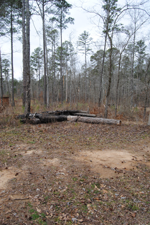
| Pharr Mounds Site |
Four of the mounds were excavated in 1966 by the National Park Service. The mounds covered various internal features, including fire pits and low, clay platforms. Cremated and unburned human remains were found in and near these mounds, as were various ceremonial artifacts, including copper spools and other copper objects, decorated ceramic vessels, lumps of galena (shiny lead ore), a sheet of mica, and a greenstone platform pipe.
The copper, galena, mica and greenstone did not originate in Mississippi; they were imported long distances through extensive trade networks. Such ritually significant non-local items typify the Middle Woodland period. The site is located on the Natchez Trace Parkway (milepost 286.7), about 23 miles northeast of Tupelo.
 |
| 13 Unknown Soldiers |
After Pharr Mounds we stopped at another 'sunken trace' site, where the original Natchez Trace was traveled hundreds of years ago. This stop (milepost 269.4) was different though, as the Civil War had left its mark. Although the Old Trace had been abandoned by the start of the war, soldiers marched, camped and fought along portions of the historic road. At this location, you can see the grave sites of 13 unknown soldiers. The marker near the graves indicates no one really knows who they are or how they died. But tradition holds that they belong to Confederate Soldiers who camped along this stretch, and either died from their wounds, or the lingering hunger, poverty an sickness in the army camps.
 |
| Confederate Grave |
Today, their simple grave markers face backwards toward the Trace so that travelers might read and remember. And many apparently still do. We found coins laid on the top of the grave stones, as well as flowers and flags by each. It was another reminder of the horrible sacrifice thousands of American's paid as our country was ripped apart by the Civil War.
 |
| Exhibit inside the Parkway Headquarters |
Before we exited off the Trace at Tupelo, we visited the Parkway Visitors Center (mile post 266). This is the Natchez Trace Parkway Headquarters and well worth the stop. Exhibits about the history of the area, the Trace and it's origins, as well as how it became a National Parkway are all here, as well as a friendly staff ready to answer questions on most anything related to the Trace. We even got some tips on Natchez, Ms for our upcoming visit to the historic city.
It was a somewhat short travel day for us, and we wanted to find a place to land for a few days to catch up with our on-line stuff, so we went into Tupelo and found a beautiful RV Park just on the outskirts of town. Unfortunately beauty wasn't what we were after, we just wanted some solid Wifi time. Despite the RV Parks best attempt at providing Wifi throughout the complex, we had problems connecting, so only spent one night.
(Note: Related RV Park Reviews at the end of this article)
 |
| The King - Elvis Presley |
Although we didn't do Tupelo, there is lots to see and do here. While Tupelo may be the most famous for being the birth place of Elvis Presley, it's also home to the largest antique car collection east of the Mississippi River at the Tupelo Automobile Museum. In addition, according to the Mississippi Official Tour Guide, Tupelo Buffalo Park has one of the largest herds in the east, as well as other exotics, and one of the best petting zoos in the area.
Being right next to the Natchez Trace Parkway, as well as having plenty of family entertainment, Tupelo is a great stop for any traveler. If we had a different agenda on this trip we probably would have visited the Elvis Presley Birthplace and Museum. It includes the home that Elvis' father built, an Elvis statue with his first guitar, memorial chapel, a park, story wall, gift shop and more on newly expanded grounds.
 |
| Tupelo Automobile Museum photographer unknown |
Of course, the Civil War also touched this area, with two of the final battles of Mississippi, Brice's Crossroads, and the Battle of Harrisburg nearby. The Tupelo National Battlefield, a one-acre monument on Main Street in Tupelo, is the site of the July 14, 1864 battle of Tupelo, when Union Troops, including Colored regiments, marched into Tupelo and met an unorganized Confederate force. Involving over 20,000 men, neither side would be able to claim victory, however, the Union achieved its goal of keeping the Confederates away from Union railroads in Tennessee. The battle would rage until the afternoon of July 15. Notably, this would be the last time Confederate General Nathan Bedford Forest's famed cavalry troops would fight the Union, and Forest himself was injured and taken out of action for up to 3 weeks.
Back on the Trace at Tupelo to French Camp

We were back on the Trace sooner than expected on a hunt for an RV Park with adequate Wifi, so we headed south toward French Camp, where we planned to divert off the Trace to Louisville, Ms. We missed the Chickasaw Village site (milepost 261.8), which has some exhibits portraying the daily life and history at a village that once stood there. It features a self-guiding trail as well.
However, we did stop at the site of the Chickasaw Council House (milepost 251.1). Only a marker along the Trace nearby its original location, the Council House was in the village of Pontatock, which in the 1820s became the Capitol of the Chickasaw Nation. Chiefs and other leaders met here to sign treaties or establish tribal laws and policies. Each summer two or three thousand Indians camped nearby to receive the annual payments for lands they had sold to the Federal Government. The Treaty of 1832 would see the last land surrendered though, and the Chickasaw Council House disappeared. The Chickasaw tribe moved west to Oklahoma where they remain today.
 |
| Marker for the former site of Tockshish on the Natchez Trace |
Monroe Mission Station has its own marker (milepost 245.6), remembering where the Chickasaws first received Christianity and education in 1822. By 1827 81 students were attending the school, with boys learning farming and carpentry, and girls learning spinning and weaving in addition to classroom work. Monroe and three other stations were training centers for many who became leaders of the Chickasaw Nation in Oklahoma.
 |
| Hernando de Soto |
Also near here, another two miles south (milepost 243.3) Spanish Explorer Hernando de Soto crossed the animal paths that later became the Natchez Trace. In 1539 he set out on a journey that would take him across the Southeastern US. In 1540 near this marker he spent the winter among the nearby Chickasaw Natives. After a dispute with the Indians, de Soto and his army moved westward.
You can read more about Hernando de Soto HERE.
Another couple of miles south (milepost 241.4) is a marker for the Chickasaw Agency. These were all important United States agents who lived here from 1802 to 1825 along the trace. The fact that Americans could peacefully travel the road through Indian lands was due in large measure to the agents. Their efforts to preserve harmony included collecting debts, recovering stolen horses, removing trespassers, and capturing fugitives. Although Winters were lonely for the agents, during the summer months "Kaintucks" on their long journey from Natchez to their Ohio Valley homes would travel the Trace by the thousands. Many of them expected the agency to supply medicine or food and a good night's rest.
 |
| Witch Dance |
 |
| Bare spots at Witch Dance |
The Chickasaw and the Choctaw Indians in the area immediately began to avoid the scorched patches of ground. During the War of 1812 and the Creek War that followed, Andrew Jackson often traveled up and down the Natchez Trace. Though there is no indication that he feared the spots, they were interesting enough that he recorded them in his journal.
Read about the Native American Lore and Legends of Witch Dance on the Trace HERE.
Another mile south (milepost 232.4) is Bynum Mounds. Built between 2,100 and 1,800 years ago, the six burial mounds range in height from five to 14 feet. Five of them were excavated by the National Park Service in the late 1940s. The two largest mounds have been restored for public viewing. Mound A, the southernmost of the two restored mounds, contained the remains of a woman placed between two parallel burned oak logs at the mound's base. Three additional sets of human remains were also found, consisting of the cremated traces of two adults and a child.
 |
| Bynum Mounds |
You can read more about the Mississippi Mound Builders HERE.
Line Creek (mile post 213.3) is the former boundary between the Chickasaw and Choctaw Tribes. Unlike many Indian nations who seldom recognized boundaries to their lands, the Chickasaw and Choctaw came to accept this stream as the dividing line between them, and it remained so until both tribes were moved to Oklahoma in the 1830's. Near this marker, Noah Wall and his Choctaw wife had a stand where food and shelter were provided to travelers along the Trace. Pigeon Roost (mile post 203.5) is where Nathaniel and David Folsom ran Folsom's stand and trading post, and where millions of passenger pigeons, now extinct, roosted here.
 |
| Driving through the Tornado ravaged area of the Natchez Trace. |
 |
| The April 2011 Tornado's left miles of destruction on the Trace. |
According to the National Park Service, while they did remove all the downed and damaged trees from the immediate roadway, they left the rest to provide food and habitat for the many animals that call the Parkway home. "By allowing nature to take its course, visitors can see firsthand the ecosystem's resiliency in response to dynamic forces" the NPS website states. "As you visit the Parkway in the years to come, you will notice subtle changes that demonstrate the natural processes that are constantly going on around us. As time passes, the downed trees will decompose, providing nutrients to the soil for the next generation of growth. In time, nature will reclaim this area." Until then however, this area is a big reminder of how powerful weather can be, and how much you should pay attention to your surroundings while visiting any National Park. While there were thousands of people on the Natchez Trace that day in 2011, only one person perished in the storms that hit here. Unfortunately that was not the case across the state of Mississippi and other parts of the Southeast.
 |
| Original part of the Trace |
After we emerged from the tornado stricken area we ran into more "Old Trace" (original part of the historic road at mile post 198.6) and Jeff Busby picnick area and campground (mile post 193.1). Named for Mississippi U.S. Congressman Jeff Busby, who in 1934 introduced a bill authorizing a survey of the Old Natchez Trace, which just four years later became a unit of the National Park System, this is a great stop for camping, including an RV Campground.
 |
| View from the top of Little Mountain |
 |
| French Camp Historical Area |
You can see our updated story, with mile by mile points of interest along the Natchez Trace Parkway HERE.
We didn't get back on the Trace at French Camp, instead heading off toward Louisville, Ms where we would park the Trailer and catch up on things. Found a very nice RV Camp Ground and more just outside of Louisville at Lake Tiak-O'Khata Resort and planted ourselves for a few days. One thing about traveling like this in an RV and running your business from it at the same time...our pace is our own.
Next up, we head to the historic area around Jackson and Vicksburg. In the meantime, enjoy the slide show from the Natchez Trace, or visit the Winter History Tour Gallery "Natchez Trace" HERE.
primary information sources - National Park Service
_______________________________________________
RV Park Reviews
Campground at Barnes Crossing - Tupelo, Ms - Just as you enter Tupelo after exiting the Natchez Trace. Reserved and paid two nights due to advertising that Wi-Fi was available at all campsites. Unfortunately Wi-Fi did not work hardly at all while we were there. Pull through site was uneven and a little difficult to get into due to concrete retaining wall on one side. Nicely landscaped, beautiful campground with tiered levels, very close to shopping and services. Full Hookups and Cable TV. Left after one night and received refund for second night without a problem due to our immediate needs for Wifi. Not a Passport campground, rate $32 a night. We gave this one 6 out of 10.
Lake Tiak-O'Khata Resort - Louisville, MS - This site was more than adequate for our purposes, which was to catch up on work. For leisure travelers it's even better. Lake front spots available, full hookups, level slabs, cable, and Wifi. Wifi could be iffy in some spots, but talk to management and they will guide you accordingly. Rates were good ($20 per night). Cable was good, however HD channels iffy. Had to dig through leaves a bit to find the water and sewer hookups, but tis the season. Roads were a little rough coming in and could use some maintenance. Pet friendly. Would stay here again. We gave it an 8 out of 10 rating, although some reviewers noted problems negotiating into their spots (probably longer trailers).
(Note: We use RV Park Reviews. Traveling in a 22' Travel Trailer. All electric 30 amp or more unless otherwise noted).
No comments:
Post a Comment