Showing posts with label Texas. Show all posts

Friday, July 26, 2013

Las Vegas, NM to Stinnett Tx, via Route 66 and the Old West

Dilia Church
Wrapping up in the Las VegasNew Mexico area, we headed south on I-25 for just a few miles, then picked up Highway 84 to just west of  Santa Rosa. This is a stretch of Pre-1937 Route 66 in New Mexico before it was straightened out, cutting off this northern loop that used to go through Santa Fe.


Along the way to Santa Rosa you'll pass through a couple of spots in the road. Like Apache Springs with just a few scattered houses and some ruins off the side of the road, and Dilia which shows a little more life, but still a small ranching/farming community.  We experienced beautiful landscapes as we continued down in elevation, full of "nothingness" but gorgeous at the same time.

After a small jaunt on I-40, we veered back onto the Mother Road at Santa Rosa,
Sun N Sand in Santa Rosa
the City of Natural Lakes. Founded in 1865, the town began as nothing more than a large Spanish Rancho, and was called Aqua Negro Chiquita. Sometime around 1890, it took a new name honoring a chapel built by Don Celso Baco who named it for his wife and Saint Rose of Lima, the first canonized Saint of the "New World." Today, this popular town along America's Mother Road still provides area attractions through nearby lakes and streams, as well as plenty of photo ops through town of some of it's decades old and still operating Route 66 Icons.


Old Motor Court in Newkirk
Between  Santa Rosa and Tucumcari is what we refer to as a ghost town stretch of Route 66 that includes Cuervo, Newkirk and Montoya.  These small towns got their start from Ranching and Railroad and for a time they were bustling with activity from the many travelers of Route 66.  Today they are a shell of their former self with very few residents.  The buildings tell of a time before the interstate when these small communities were important stops. Read more about this stretch HERE.


Blue Swallow Motel 
After the ghost town stretch you'll find plenty more photo ops and some tasty choices in Tucumcari. Heading east into town you will first come to the New Mexico Route 66 Museum, dedicated to exploring the states 604 miles of original Mother Road.  Up and down 66 through town you'll find icon after icon, like the famous Blue Swallow Motel, or Del's Restaurant (mighty tasty mexican food by the way..loved our lunch here). Once nicknamed "Six Shooter Siding", this town started around 1901 with the railroad and quickly became a bit rowdy with saloons, gamblers, dance hall girls and the like. Today travelers can get a great feel for the 1940's and 50's era of the Mother Road as many of the businesses have done a great job keeping up the Neon, and others have been painted with Route 66 themes.

This would be all of the Mother Road on this segment of the trip though, as we cut north on Highway 54 for an overnight stay in Logan, just outside of Utte State Park, on our way to more old west history in the Texas Panhandle.  (Stayed at Arrowhead RV Park on the east edge of town.  Under new ownership for about a month, this was an alright stop for the night with full hookups, but was mostly long term campers working in the area. A little TLC, which the owner is in the process of giving, will go a long way here. Paid $15 (tax included) with our Passport membership). 

Logan to Stinnett and Hutchinson County History


At one time this bar was a bank
Not too far down the road from Logan on Highway 54 we came into Nara Visa, a ghost town lovers delight. This early 1900's town was built on the railroad, and started off as Narvaez, but English speaking settlers managed to mangle the name until it became Nara Visa. What is now just a small town with an open post office and Motel on the western end used to be home to several churches, eight saloons, dance halls, stores, and more.  What used to be the bank, turned into a bar and looks like something we've seen in a movie, but couldn't find anything in our immediate research.

This was a gem of photo ops for Kathy and I, but unfortunately for "me", my camera decided it was time to
There were quite a few old vehicles on
property along the highway in Nara Visa.
retire, so Kathy got all the fun.  We also heard from a reader on our Facebook page that the bank (now closed bar), which was the First National Bank of Nara Visa, was at one time the most robbed bank in the United States, including, according to our reader, by the Pretty Boy Floyd gang.

After some quality time in Nara Visa, we pushed onto the Texas Panhandle for Cal Farley's Boys Ranch, which used to be the Old West town of Tascosa.  This was once a rival to Dodge City for cattle markets, and was the capital of 10 counties. The post office was established in 1878, and by the 1880's it was already a rough town, famously known for a gun fight in 1886 at the Jenkins Saloon between two panhandle ranch factions that left four dead.  You can visit their graves at the Boot Hill cemetery on the way into town.

Once in Cal Farley's Boys Ranch you need to check into the main office, then walk across the street to the Julian Bivins Museum, housed in the original courthouse.  It, and the old school house are the only two original structures remaining from Tascosa, which died as a town after the railroad built 50 miles north of town.  By the 1930's the town was dead and Cal Farley's Boys Ranch was built on the site in 1938.

From Cal Farley's we headed onto our destination for the next couple of days, Hutchinson County seat Stinnett Texas.

For Legends' 10th Anniversary, Kathy wanted to pay tribute to her roots in the Texas Panhandle, as it was her Grandmother Irene Foster which gave her the "history bug" as a child.  Hutchinson county has a pretty interesting history, especially with the oil industry.  Like the wild and wooley town of Borger just a few miles down the road from Stinnett that was once so corrupt that the Governor of Texas had to send in the Texas Rangers. You can read our full story on Borger HERE.

Stinnett wasn't always the county seat. The extinct town of Plemons held that honor for several years after getting it's start in the late 1800's.  Hutchinson county is also home to Adobe Walls, the first trading post in this region established back in 1843.  Just a marker in a field now, Adobe Walls also has the grave of William Billy Dixon, famous scout, buffalo hunter and Indian Fighter.  Dixon was involved with the second "Battle of Adobe Walls", and is credited with being a hero two days into the battle, when a bullet from his Sharps buffalo rifle knocked an Indian off his horse nearly a mile away (perhaps exaggerated. Dixon himself never claimed credit for his "long shot."


Irene Womble Foster, the
inspiration for Legends Of America.
Kathy's great grandfather William Carson Womble settled in the area around 1902 and was good friends with Dixon up until Dixon's death in 1915.  Womble would go on to become a county commissioner and played an important role in building the new county courthouse in Stinnett in the 1930's, which has his name engraved in the cornerstone of the building.  Later, Kathy's grandfather Ben Foster (who married Irene Womble whom Kathy dedicates Legends Of America too) became the mechanical engineer for the courthouse.  He and Irene would live in the basement apartment at the building for years, raising their children there.  We took a tour of the courthouse so Kathy could relive childhood memories of playing in the halls.  Heard a lot of "tales" from her on this trip about life at the courthouse, from sneaking into the library, to her mom, Wanda, climbing out on the upper floors ledge as a child and actually walking around the building.

Kathy's written extensive history on Hutchinson County, it's towns and people which you can see HERE. Be sure to visit the link for Extinct Towns, Ghost Towns and Company Camps to see more about Plemons and other places that used to be part of the rich history here.

You can see our trip in photos via our Facebook photo album HERE.

(We stayed a couple of nights by the city park in Stinnett in a small (3 or 4 space) RV parking area.  Full hookups, and it was "Free" for 3 nights, then $10 per night after [no long term campers].  We think it's great promotion for a city to do this, and loved the fact we could take advantage of it.  The only thing we would suggest is that the city perform the same care with the RV area that they do with the park, as it was full of good ol' Texas stickers and hardly any grass)

Wednesday, February 23, 2011

The Beginning of the End of Our West Texas Adventure - Del Rio to San Antonio

With Waylon and Willie and the Boys
After several weeks exploring West Texas from our temporary home in Del Rio, we packed up the dog and decided to start making our way back home.  We knew that this would be a long journey back to Missouri, as we still had a lot to see, including one of our premiere destinations, San Antonio.  So Tuesday morning we headed north out of Del Rio on highway 277 up to Sonora, and made a roundabout trip over towards Fredericksburg.  This was a day full of views and history, including Roosevelt, Junction, the ever beautiful and fantastic Fredericksburg, and the little old town of Luckenbach. Read about these places and more by following us through photos in our Facebook Album here.

We'll blog a lot more about San Antonio next, as we continue our journey home to Warsaw, Mo.

Tuesday, February 22, 2011

Pecos to Del Rio via Fort Stockton

When you come into Pecos on I-20 from Toyah, you might think this is a pretty big town.  However, once you get past the string of Hotels along the Interstate, you realize that the main part of town is much removed from the hustle and bustle of the Interstate, and the reason for the hotels is simple.  There's not a lot going on in this part of West Texas, and for many, this is the only option for an overnight stay. That might also explain why the speed limit in this part of Texas is 80mph.  People tend to want to move as fast as they can back to civilization.

West of the Pecos Museum Saloon
We had a pretty long day when we pulled in, so it was nice to find the comfortable room at the Quality Inn after being turned away by other hotels.  A little exploring the next morning, after a nice tasty breakfast at Abi's Kitchen, found us at West of the Pecos Museum.  Located in an 1896 Saloon and 1904 Orient Hotel, this gem of West Texas is an internationally recognized historic landmark and a must stop for history lovers.  The Saloon has been restored and tells the story of the infamous gunfight between Barney Riggs and the henchmen of the notorious Jim Miller.  Three stories of rooms filled with area history are well worth the small admission price. While your there, make sure to go outside to see the grave of famed gunfighter Clay Allison.  And before heading out of Pecos, be sure to see the Pecos Rodeo grounds, home of the Worlds First Rodeo.  I'm sure some of you are saying that couldn't be, but Pecos is home to the first rodeo that offered prize money.

Paisano Pete, the Worlds Largest Roadrunner
We didn't get back on I-20, opting instead to head south on Highway 285 back to I-10 and Fort Stockton.  Lot's of history here with an Historic Downtown, the Annie Riggs Memorial Museum, and of course Fort Stockton Military Post, established in 1859.  This is a nice place to visit and shop the quaint shops in downtown, along with soaking up the history of this favorite rest stop along the Comanche Trail to Chihuahua, San Antonio-El Paso Road, The Butterfield Overland Mail Route, and the San Antonio-Chihuahua freight-wagon road.

A Scenic Overlook above Ft Lancaster
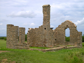
From Fort Stockton, we head East down I-10 and cut off onto Highway 349 for a side trip to Fort Lancaster.  The old post is located about ten miles east of Sheffield in Crockett County. It was one in a series of forts erected along the western Texas frontier,  established in August,  1855, to guard the military supplies, commercial shipments, and immigrants moving along the San Antonio-El Paso Road. Today, there is little left of the old post but ruins. Fort Lancaster was abandoned by the U.S. Army during the Civil War, at which time it was taken over by Confederate troops from December, 1861 through April, 1862.  It was then abandoned and the buildings began to deteriorate from vandalism and the harsh climate.  The drive is scenic however and it's worth a stop for history buffs.

Crockett County Courthouse
Back onto I-10 we head to Ozona, called the "Biggest Little Town in the World."  Ozona is the only city in Crockett County, which encompasses over 3,000 square miles, and sports a population of around 3400.  Crockett County was founded in 1875 and named in honor of Davy Crockett, the legendary frontiersman who died at the Battle of the Alamo.


Devils River
From Ozona, we get off the Interstate and start our trek back to Del Rio via scenic 163 to Comstock.  Along the way you will cross the Devil's River.  Near here once stood Camp Hudson, established by the U.S. Army in June, 1857 to protect the San Antonio-El Paso Road against hostile Indians. The post was evacuated during the Civil War, but, re-occupied afterwards. It was abandoned again in April, 1868. Unfortunately, there are no remains today. This area, also called Baker's Crossing is a popular entry point for rafters along the river.

Getting back to Del Rio we feel we have seen what we came for in this part of West Texas, and start making plans to wrap up our extended stay and head home.  Of course, it won't be a direct route, as there is much more to do, including Sonora, Fredericksburg, and a little town made famous through music on the way to San Antone, one of our premiere destinations of our long journey in the Lone Star State.

In the meantime, follow this part of our trip in pictures via our Facebook album here.

Monday, February 21, 2011

North from Shafter to Pecos

Wild Rose Pass north of Fort Davis, Texas
Our round trip from Del Rio, through Big Bend and North to Pecos continues with a jaunt from the Mexican Border area to the Ghost Town of Toyah Texas.  There were a lot of great stops on the way, including historic Fort Davis.  This is another one of those times though that the story can best be told through pictures, so follow us in photos with our North to Toyah Facebook album here.

Thursday, February 17, 2011

On the Way to Big Bend

We headed out from our temporary home base in Del Rio Tx on Monday morning for a 3 day excursion through West Texas, including Big Bend, Ft. Stockton, Pecos and more.  Our first day got us to Big Bend.  Rather than blog about that part of the trip here, I thought it would be more appropriate to let you see in pictures (with captions of course) what we found on the way.  You don't have to be a Facebook Member to see these photos.

Just follow the link
http://www.facebook.com/album.php?aid=281129&id=110001784731

We'll blog about our other two days soon, and share more photo's via our Facebook Fan Page.

Sunday, February 13, 2011

Onwards to Langtry - Home of Judge Roy Bean

Needing much more Old West mentality than the civilized city of Del Rio can provide, we head to the northwest across what can best be described as a sagebrush desert. Some 30 miles northwest of Del Rio we come to Comstock, a ghost town, having some 300 residents, it doesn't appear to be faring extremely well. And, unfortunately, even it's buildings are not interesting enough to spend much time pushing my magic shutter button. Though it got its start as yet another railroad town in the early 1880's, it never grew very much and today, there is little left of that history. It does have an old cemetery, which is filled with far more people than live in the town today. It still features an active hotel, and, perhaps a couple of other businesses.

Moving to the northwest, we pass by the old townsite of Shumla, established in 1882 as a section station on the Galveston, Harrisburg and San Antonio Railway. Today all that is left is an old row of buildings which once served as a motel, service station, and store.
Then we're off to the Pecos River Crossing. High canyon walls dominate the last sixty miles of the Pecos River before it enters the Rio Grande River. The Southern Pacific Railoroad built the first high bridge across the Pecos River in 1891. In June 1923, the Texas Highway Department constructed an automobile bridge to replace an old canyon-bottom crossing, but, it was washed away in 1954. Two temporary low water bridges in 1954 and 1955, were also destroyed by floodwaters. This bridge was completed in 1957. It is 1310 feet long and is the highest bridge in Texas at 273 feet above the water level.

North of the highway bridge is an observation point where visitors can see the Southern Pacific Railroad in the distance. This was also the site of the town of Vinegarroon, where Roy Bean first set up a saloon in the area. When the bridge was complete, Bean moved on to Langtry. Situated on private property, neither the bridge nor the old townsite are accessible today.

Headed north once again we cross Eagle Nest Canyon. Down below on the southwest side of the bridge is a place called Bonfire Shelter. Tracing its history back more than 11,000 years, Bonfire Shelter is known as being both the earliest and the most southern bison jump site in North America. Bonfire Long before Native American obtained horses, they stampeded herds of bison off the edge of this cliff, which overhung a shelter of a box canyon that empties into the Rio Grande River near Langtry, Texas. The bridge is located just southeast of Langtry.

We then arrive at our primary destination -- Langtry, Texas, the long-time home of crazy Judge Roy Bean. The town got its start as a camp called Eagle Nest when the Southern Pacific Railroad was being built through the area. Judge Roy Bean soon arrived, after the nearby town of Vinegarron was abandoned and "set up shop" once again. He ran his court and his odd type of justice out of his saloon, which he called the Jersey Lilly, named in honor of Lillie Langtry, the actress of his dreams. Bean died in 1903 and is buried in Del Rio, Texas.

The town began to decline after the highway was moved to the north of the city and when the Southern Pacific Railroad moved its facilities away, the town nearly died, dropping to a population of just about 40 people. The town stays alive today due to tourism to the Judge Roy Bean Visitor Center and still supports a couple of businesses.

We have a great time exploring the many old buildings of Langtry, many of which are mostly on the ground. Then we're off to find its sad little cemetery. No longer used and falling into serious disrepair over the years, it still provides volumes in my imagination and shutter opportunities. We then make our way right to the edge of the United States, looking over the Rio Grande River to Mexico.
 
Then, its back the way we came, "home" to Del Rio.

Monday, February 07, 2011

Bracketville, Fort Clark & the Pecos Heritage Trail

We arrived in Del Rio on the evening of February 1st. After being on the road for several days, we needed a few days to rest and time to catch up, set up new office space, etc. Luckily we were just a day ahead of the storm most all the way - blizzards in Oklahoma, ice in Dallas, and the day after we reached Del Rio, temperatures in the 20's for several days. We didn't mind though, because, we were watching the weather at home - 18 inches of snow and temperatures in the single digits.


After catching up and staying warm for the first few days, we venture out on our first day trip to Brackettville, Texas, where we snap lots of pictures and spend time at Fort Clark. Unlike many other frontier forts that were prominent in the Indian Wars, Fort Clark, situated in south-central Texas remained an active post through World War II. It was founded in 1852 and inactivated in the mid-1940's. The southern anchor of the Texas  defense line in the 1850's, it guarded the San Antonio-El Paso Road and policed the Mexican border. We also make a visit to the  Seminole Indian Scout Cemetery about three miles south of town, which includes the graves of four Congressional Medal of Honor Recipients with service at Fort Clark. 


Brackettville, the county seat of Kinney County, got its start at the same time as Fort Clark -- in 1852. It was named after Oscar Brackett who was a sutler to Fort Clark. The community experienced a period of steady growth after the Civil War, attracting cattle rustlers, buffalo hunters, gamblers, and businessmen. There are some very interesting old buildings in the town. Seemingly, this small town doesn't tear down its old buildings, which is a photographer's heyday. Stay tuned, we'll be bringing you more on Brackettville soon.

Then we're off to do just a short stretch of the old  Pecos Heritage Trail between Brackettville and  Rocksprings. This trail, covering more than 1,300 miles provides visitors with a diverse landscape, including sand dunes, underground caverns, spring-fed pools, numerous rivers and creeks, lakes and much more. Encompassing 22 counties, seven state parks, dozens of towns, and hundreds of historical, cultural, natural, and recreational destinations, we're not going to do this in one stretch, but, rather, hit pieces of it at a time as we roam the area.


We do a quick tour of  Kickapoo Cavern State Park; but, not being much into caves, we quickly move on to Rocksprings. The county seat of Edwards County, Rocksprings received its name from natural springs that bubble forth from the porous limestone rocks in the area. Founded in 1891, the area had previously been long favored by pioneers and native peoples. The only incorporated town in Edwards County, it has a population of about 1,300. 


 We then make our way back to Del Rio to make plans for more upcoming adventures.

Wednesday, February 02, 2011

Austin to Del Rio

Our last day on the road before reaching Del Rio, starts with a bang with a personal tour of the Bob Bullock Texas State History Museum. Thanks to Linda Pybus Glover, who works with the museum and just happens to be a Legends reader, we were able to get a personal tour with wonderful history. 


The museum tells the “Story of Texas” with three floors of interactive exhibits and special effects shows, and is worthy of the Lone Star State. Unfortunately, due to the nature of the exhibits being on loan from other Texas museums, societies and individuals, we were unable to take photos to share with you. Definitely worth the visit to see for yourself! 


Then, with Del Rio still some 230 miles down the road, we plan few stops. We will return to the San Antonio area and dedicate a couple of days. The rest is day-trippable, and you will be hearing lots more.

That being said, we can't resist a stop at tiny D'Hanis, Texas, about 50 miles west of San Antonio. First established in 1847, the building of nearby Fort Lincoln in 1849 afforded the settlers employment and much-needed protection from Indian raids. By 1850, it sported 20 homes and a school. In 1854, it became a stage stop on the San Antonio-Rio Grande Road. The beautiful St. Dominic's Church was built in 1869. 


Today, only ruins are left but still worth a stop for the photo opportunity. In 1881, when the Galveston, Harrisburg & San Antonio Railway built across Medina County, it bypassed old D'Hanis, and a new town grew up around the railroad loading depot 1½ miles west. Today, D'Hanis still supports a small population and has a few remaining businesses, but a visit is like stepping back in time.


We then barrel on through to Del Rio, in search of our new diggs. We have rented a two bedroom furnished apartment that provides us with good internet, dishes; all we need for living for 30 days, and allows our little dog, KayDee. We spend the rest of the evening setting up our new "headquarters." Next morning, it's unbelievably only 26 degrees, but we weren't planning a travel day anyway. We stock up on groceries, explore the town a little, and we're back to work. By weekend, temperatures are supposed to return to normal and we will begin our adventures.

Stay tuned as we explore southwest Texas, taking in such places as Big Bend National Park, Fort ClarkFort Stockton, Langtry, the Pecos Heritage Trail and much more.


Follow us in photos via Legends page on Facebook.

Sunday, November 29, 2009

Texas to Missouri - Finding Our Way Home

We had a wonderful Thanksgiving with family in Pampa Texas and enjoyed another day of down time before heading out on Friday to make our way home. Most of the time when we come see them, we travel I-40, but knowing we weren't going to make the full way home in one day this trip, we decided to spend some quality time in North Central Oklahoma on roads less traveled.

About 20 miles east of the Texas border, and 30 miles north of I-40 near Cheyenne Oklahoma, we found The Washita Battlefield National Historic Site. This is where Lt. Col. George Custer led the 7th US Calvary on a surprise attack at dawn against a Southern Cheyenne village and the tragic slaughter of it's people. The attack was just a day after their leader, Chief Black Kettle, had returned from peace talks with the US. The Peace Chief was killed in the battle, and to this day the area is a reminder of the tragic clash of cultures that took so many lives.


Moving on down highway 283, we found our way to Highway 33 and boogied across Central Oklahoma with not much else on the agenda for that Friday, other than seeing some of the towns we usually miss traveling more major thoroughfares through the state. Like Kingfisher, situated on the Chisholm Trail and founded during the Federal Governments "Land Rush" in the late 1880's. If you make it there, be sure to check out the Chisholm Trail Museum and Governor Seay Mansion.

Eastward still on Highway 33 we pass through Guthrie, home of Oklahoma's first capitol, and across I-35 until finally meeting up with I-44 just outside of Tulsa. Doing this area quite a bit on our Route 66 travels, we decide to push on without stopping to our final destination of the day, Grand Lakes, where good friends await to put us up for the night [Thanks Susy, Jerry and Lou! We had a blast!!..oh, and Randy too for the great suggestions on places to go in South West Missouri :) ]

Coming Home....

Saturday we said goodbye to our friends and began our trek to far Southwest Missouri, winding around Grand Lake, then onto highway 59 through Copeland, eventually meeting up with highway 90 into Noel Missouri. This is one of the few "Christmas" cities in the US, where people send letters to have postmarked for the holiday, and is in McDonald county, which has a strong history of Civil War skirmishes and later became a very popular vacation destination. There were many resorts throughout the county, and touring Caves as well, including the still active Bluff Dwellers Cave near Noel.

Our bonus on this part of the trip though was finding Truitt's Cave on Highway 59 north of Noel in Lanagan Missouri. This once thriving tourist stop still has a billboard on the highway, but is abandoned after traffic found faster ways through the area on the expanded 71 highway nearby. Almost like a Route 66 relic, it fascinated both of us how something that once housed a Cave restaurant, underground wedding chapel and even a trout reservoir could be pushed aside and forgotten. A little research shows that the closing was actually pretty recent in 2004. What made our stop even more special was finding the grand children of one of the previous owners there, walking the grounds with us, reminiscing about their childhoods and just how "neat" the place really was.

Still pushing north, we made our way to Carthage, site of the Battle of Carthage, another one of the notable fights in the Civil War. Carthage has a beautiful downtown and several mansions along an historic drive through the city. It's also historic for it's role on Route 66, and of course Kathy and I could no longer resist the call of the Mother Road and just had to head east toward Springfield to at least take in a small part of it.

Along the route we made a stops at Spencer and at Paris Springs Junction, home of the Gay Parita Sinclair Station. The original building is gone, but Gary Turner and his son Steve rebuilt the 1930's era icon in 2006, and it's a great stop for all Route 66 enthusiasts. Kathy of course was in hog heaven taking pictures of long forgotten stops along the route all the way to Springfield where we finally ran out of daylight, and headed north on 65 to our home base in Warsaw.

It was a 2,200 mile round trip through Arkansas, Oklahoma and Texas, and a memorable one for sure. Thanks for following along. We have no idea where we will go next, but in the meantime we'll continue to write about the incredible stories of the American West with dreams of the road on our horizon. Be watching the "What's New" page for articles born out of our adventure.

Wednesday, November 25, 2009

Howe to Abilene - The Texas Forts Trail

We had a long way to go, and a short time to get there....hmm, haven't I heard that in a song? Either way, we didn't start our travel until after lunch, saying goodbye to family in Howe, Texas, we hit highway 82 out of Sherman to I-35, south to Denton, then highway 380 west to Jacksboro, home of Fort Richardson.

The northernmost post of a line of forts stretching from the Rio Grande to the Red River, Fort Richardson played an important role in conquering the native Plains Indians and forcing them onto reservations north of the Red River. Now a National Historic Lnadmark and Texas State Park, seven original buildings remain and have been restored, along with two replica fort buildings. If you're an RV'er, this park has several nice campsites to take advantage of.

Fort Richardson is also the home of the "Lost Battalion", a group of Texas National Guardsmen who were mobilized at the site during World War II and eventually were captured in Java, spending the rest of the war as prisoners. A historic marker at the park commemorates them today.

From Jacksboro we moved on down 380 to Graham, home of the largest town square in the US, then up FM61 to Fort Belknap, which is now simply a county park. The fort was used mainly as a base of operations and served as a hub for a network of roads, including the Butterfield Overland Mail. Abandoned prior to the Civil War, partly due to a lack of water, portions of the fort have been rebuilt on their original foundations, and it remains a National Historic Landmark.

From Fort Belknap north on FM61, back onto highway 380 to Throckmorton, we start our final trek of the day south on 283 toward Abilene with Fort Griffin on our mind. Late in the day, we didn't get to see all we wanted, but Kathy has actually been here before so we're covered. Little remains standing of this fort, originally named Fort Wilson, but renamed in honor of Major General Charles Griffin of the Texas Army Department, who made the original fort plans. The soldiers at the fort stayed busy keeping the Indians in check during the Red River Campaign which continued through 1874, meanwhile the town that formed nearby had a history of lawlessness as ruffians and outlaws moved in.

Several notable figures of American history are tied to Fort Griffin. Doc Holliday and Wyatt Earp first met there. Gambler Big Nose Kate, lawman Pat Garrett and gunfighter John Wesley Hardin also spent time there.

Traveling from Fort Griffin to Abilene the sun was quickly setting on our day, but not before we got to see an ironic sunset. Well, not sure I should call it ironic, but a horizon dotted with huge wind mills intermingled with Oil Rigs is strange in my books.


We are using Abilene as a home base for a couple of nights. On our next blog, we'll take you south through the true Heart of Texas and back as we continue to explore the Texas Forts Trail. Also be watching our "What's New" page for stories on Fort Richardson and Fort Belknap coming soon.